Engagingly written — all the guides from this stable are first class
— Traveller
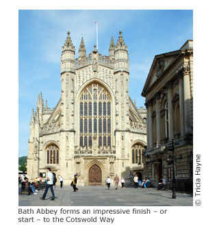
Cotswold Way: Chipping Campden to Bath
Excerpt:
Using this guide
Contents | Introduction | About the Cotswold Way | Planning your walk | Using this guide | Sample route guide: Birdlip to Painswick | Stage Map and Trail Profile sample
The route guide and maps have not been divided into rigid daily stages since people walk at different speeds and have different interests. The route summaries below describe the trail between significant places and are written as if walking the path from north to south.
To enable you to plan your own itinerary, practical information is presented clearly on each of the trail maps. This includes walking times in each direction, places to stay and eat, as well as shops where you can buy supplies.
Further service details are given in the text; note that the hours stated for pubs relate, for the most part, to when food is served; most venues serve drinks outside these hours.
For map profiles see the colour pages at the end of the book.
For an overview of this information see itineraries (pp30-8) and the village facilities table (pp34-7).
The cumulative distance chart is on p194.
TRAIL MAPS
Scale and walking times
The trail maps are to a scale of 1:20,000 (1cm = 200m; 31/8 inches = one mile). Walking times (see box below) are given along the side of each map and the arrow shows the direction to which the time refers. Black triangles indicate the points between which the times have been taken. The time-bars are a tool and are not there to judge your walking ability. There are so many variables that affect walking speed, from the weather conditions to how many beers you drank the previous evening. After the first hour or two of walking you will be able to see how your speed relates to the timings on the maps.
Up or down?
The trail is shown as a dotted line – – –. An arrow across the trail indicates the slope; two arrows show that it is steep. Note that the arrow points towards the higher part of the trail. If, for example, you are walking from A (at 80m) to B (at 200m) and the trail between the two is short and steep it would be shown thus: A– – – >> – – – B. Reversed arrow heads indicate a downward gradient.
Accommodation
Accommodation marked on the map is either on or within easy reach of the trail. Where accommodation is scarce, however, some of the places listed are a little further away. If that is the case, many B&B proprietors will collect walkers from the nearest point on the trail and deliver them back again the next morning, if requested in advance. They may also be happy to transfer your luggage to your next accommodation place on the map. Some may make a charge for either or both of these services. Check the details at the time of booking. Details of each place are given in the accompanying text.
The number of rooms of each type is stated, ie: S = Single, T = Twin room, D = Double room, Tr = Triple room and Qd = Quad. Note that most of the triple/quad rooms have a double bed and one/two single beds (or bunk beds); thus for a group of three or four, two people would have to share the double bed, but it also means that the room can be used as a double or twin. See also pp18-19.
Rates quoted for B&B-style accommodation are per person (pp) based on two people sharing a room for a one-night stay; rates may well be discounted for longer stays. Where a single room (sgl) is available, the rate for that is quoted if different from the rate per person. The rate for single occupancy (sgl occ) of a double/twin may be higher and the per person rate for three/four sharing a triple/quad may be lower. Unless specified, rates are for bed and breakfast. At some places the only option is a room rate; this will be the same whether one or two people (or more if permissible) use the room. In tourist towns, particularly, you can expect to pay extra at weekends (whereas in the odd business establishment the rate is likely to be higher during the week). Note that some places accept only a two-night stay, particularly at weekends and in the main season.
Your room will either have en suite (bath or shower) facilities, or a private or shared bathroom or shower room just outside the bedroom.
The text also indicates whether the premises have: wi-fi (wi-fi); if a bath () is available either as part of en suite facilities, or in a separate bathroom – for those who prefer a relaxed soak at the end of the day; if a packed lunch (â“) can be prepared, subject to prior arrangement; and if dogs (see also p25 and pp187-8) are welcome, again subject to prior arrangement, either in at least one room (many places have only one room suitable for dogs), or at campsites. The policy on charging for dogs varies; some places make an additional charge per day or per stay, while others may require a refundable deposit against any potential damage or mess.
Other features
The numbered GPS waypoints refer to the list on pp185-6. Generally, other features are marked on the maps when they are pertinent to navigation. In order to avoid cluttering the maps and making them unusable, not all features have been marked each time they occur.
Cotswold Way: Chipping Campden to Bath
Excerpts:
- Contents
- Introduction
- About the Cotswold Way
- Planning your walk
- Using this guide
- Sample route guide: Birdlip to Painswick
- Stage Map and Trail Profile sample
Price: £14.99 buy online now…
Latest tweets