Practical guidebooks for the more adventurous traveller.
— The Herald
The Ridgeway: Avebury to Ivinghoe Beacon
Excerpt:
Sample route guide: Foxhill to Court Hill (& Wantage)
Contents list | Introduction | About the Ridgeway | Planning your walk | Using this guide | Sample route guide: Foxhill to Court Hill (& Wantage)
FOXHILL TO COURT HILL (& WANTAGE) MAPS 10-16
Overview
This second stage of the Ridgeway totals 111/2 miles/18.5km (33⁄4-51⁄2hrs); on
the whole the walking is easy along very broad grassy tracks. Although there
are a few ascents, they’re not too draining. There are some great views plus
several interesting archaeological sites and natural phenomena worth investi-
gating. This is also the most remote section of the Ridgeway and is completely
exposed to the elements with little shelter available. If it rains there is little you
can do but continue walking and get very wet.
HERE IS AN EXTRACT
Route
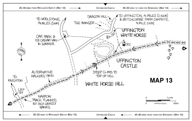
The climb up White Horse Hill to Uffington Castle (Map 13) is on a good
track but it certainly gets steep towards the top; this is the toughest climb of this
section but it doesn’t last for long so count yourself lucky.
The National Trust area around this hill contains not only the aforemen-
tioned Uffington Castle and Uffington White Horse but also The Manger, a
stunning coombe, lined with terraces, best viewed from the White Horse itself,
and the perfectly formed, flat-topped Dragon Hill, just north of the White
Horse, where St George battled with and slew the dragon.
Uffington Castle is the third of the big Iron Age hill forts you will have
passed – the previous two being Barbury Castle (see p92) and Liddington
Castle (see p97). The setting is certainly no less dramatic than Barbury’s,
though it’s seven metres lower and only two-thirds its size. The double banks and ditches are still steep and well defined and the views from up here are magnificent.
â White horses
The Uffington White Horse (see Map 13) is the one that inspired them all. Scientists
now think, after much debate, that it was first cut into the hillside around 800BC. It’s over
100 metres long and superbly suggests the form of a horse rather than simply defining its
outline. It’s a mystery how the creators of the horse could cut it so well, given that the
whole horse is only properly viewable from around a mile (1.5km) away in the valley.
Without a shadow of a doubt, Uffington White Horse is the best of the lot, but
there are various other white horses scattered around the countryside near here. None
of them is nearly as ancient and they don’t even get close to the fluid beauty of the
Uffington horse. By the time you reach this horse you’ll have already passed another
example at Hackpen Hill (Map 3) that was cut into the hillside in 1838.
The oldest and one of the most visible of all the modern horses is the Westbury
White Horse. This was cut in 1778 but at some point in the 1950s it was concreted
over. The concrete was then painted white. Owing to some unsightly deterioration and
discolouration in the concrete, the horse was given another coating of concrete and
paint in 1995. The logic was that concrete is easier to maintain. Using that logic
maybe we should concrete over the Ridgeway, too? Cherhill White Horse is on a hill
of the same name that is south of the A4 near Cherhill village, 33/4 miles/6km west of
Avebury. This horse is one of the older ones in the area having been cut into the hill-
side in 1780. It was fully restored in 2002 and is easily visible from the A4.
There are other white horses: between Milk Hill and Walkers Hill, close to the
village of Alton Barnes, about 33/4 miles/6km due south of Avebury is a good speci-
men, cut in 1812 and cleaned up in 2002. There is a further example of a well cared
for horse near Broad Town on a north-west-facing slope. This horse is about 5km
north-west of the Hackpen Hill horse though it’s unclear when it was cut – probably
in the 1860s. On Pewsey Hill, just south of the village of Pewsey, about 41/4 miles/7km
south of Marlborough, is a well-groomed 1937 white horse.
The youngest white horse in the area is on Roundway Hill in Devizes, about 71/2
miles/12km south-west of Avebury. It was created for the millennium and is uncom-
mon in that it faces to the right. There was a much older white horse close to here but
it has long since disappeared.
There is now a recognised White Horse Trail that follows a roughly circular route
and visits all the white horses in Wiltshire. The trail is around 90 miles/145km long and
illustrated guides can be bought from tourist information centres in the area.
For further information visit www.wiltshirewhitehorses.org.uk.
Uffington White Horse lies on the side of the hill to the north of the fort
and although it really is spectacular this is certainly not the best place from
which to view it. In fact it’s very difficult to get a good view of the horse from
the ground. Short of hiring a helicopter, the better views are from down in the
valley: a steep descent and a very disappointing walk back up. If you don’t think
you can manage it, don’t worry – even from down there the views are frustrat-
ingly incomplete. Perhaps remember to drive along the B4507 (the road running
parallel to the Ridgeway along here) another time for views of the horse.
The White Horse Hill area really is one of the highlights of the Ridgeway
trail so do take some time out to relax here and enjoy it. You’ve also got a
fairly long stretch of plodding ahead, so you’ll need the energy.
If you have decided to finish your day’s walking at this point, you can walk
down to the campsite at Britchcombe Farm (☎ 01367 820667; 70 pitches, 3
tipis and 1 yurt); the location is hard to beat. Pitches are £7pp per night including
use of the shower/toilet facilities. You are also allowed to have an open fire as
long as it is on a site where there has previously been a fire and also is not near
the tents – bags of firewood are sold by the campsite owner. The tipis and yurt
cost from £60 per night (plus the pitch fee above; from £90 for two nights) and
sleep up to four people. They share toilet/shower facilities with the campsite and
you need to bring your own bedding. There is also a tearoom called The Teapot
(Mar-Dec, weekends and Bank Holidays 3-6pm) that serves cream teas.
This is also the place to leave the trail and head down to the village of
Uffington, if you so desire.
UFFINGTON
It’s a bit of a trek to get to Uffington from the Ridgeway, and certainly a strenuous
start to the day if walking back up to the trail, but there a couple of very good places
to stay here, along with a decent pub, a shop with a post office, and even a museum.
Tom Brown’s School Museum ( www.museum.uffington.net; Easter-end
Oct, weekends and Bank Holidays only, 2-5pm, free admission) is logically located
in the classroom featured in the 1857 novel Tom Brown’s School Days by Thomas
Hughes. Exhibits centre on local history and archaeology.
The Post Office and Stores (☎ 01367 820221; Mon, Tue, Thur & Fri 7.15am-
5.30pm, Wed 7.15am-2pm, Sat 7.30am- 4pm, Sun 8.30am-noon; post office Mon,
Tue, Thur & Fri 9am-5.30pm, Wed 9am- 1pm, Sat 9am-12.30pm) is well stocked
with groceries and general supplies. However, they are expecting to move
to a new site during 2012 and the opening hours may change at that time. When they
do move there will be directions from the current site to the new one.
In the centre of the village is the cream-coloured Norton House (☎ 01367
820230, www.smoothhound.co.uk/ho tels/nortonfaringdon; 1S shared bathroom,
1D/1D, T or F, both with private bathroom; which offers B&B in a large 18th-
century family home. The double is £60, the single is £35-40 and the family room
costs £90-100. Packed lunches are available and the owners can pick you up from,
or drop you off at, the Ridgeway which could be a godsend if you’re finding the
going a bit tough.
The Ridgeway: Avebury to Ivinghoe Beacon
Excerpts:
- Contents list
- Introduction
- About the Ridgeway
- Planning your walk
- Using this guide
- Sample route guide: Foxhill to Court Hill (& Wantage)
Price: £12.99 buy online now…
Latest tweets