Engagingly written — all the guides from this stable are first class
— Traveller
Dorset & South Devon Coast Path (South-West Coast Path Part 3)
Excerpt:
Sample route guide: Bigbury-on-Sea to Salcombe
Contents | Introduction | How difficult is the path? | Planning your walk | Using this guide | Sample route guide: Bigbury-on-Sea to Salcombe
BIGBURY-ON-SEA TO SALCOMBE [Maps 11-16]
The coast path for this 13-mile (21km; 5hrs 5mins) stage continues to be fairly remote and wild though there are, thankfully, more places on the way where you can get refreshments than on the previous stage.
The highlight – other than the scenery, of course, particularly during the latter half of the walk which is just unremittingly breathtaking – is the likeable village of Hope (or Outer Hope to give it its full title and to distinguish it from neighbouring Inner Hope, to the south). Overall, it’s one of those stages where you should pray for fine weather; if your prayers are answered you can expect the memory card in your camera to be pretty full by the end of the day.
However, before you set off make sure you have checked the ferry times for this section of the path.
The route
As before, the day begins with a crossing of a river, in this case the Avon (no, not that one). Getting to the ferry launch is a little tricky: from the beach at Bigbury, the path meanders close to – or on – the road out of the village up to Mount Folly Farm, which it cuts through on its way, via a sheep field or two, down to the ferry at Cockleridge Ham.
TACKLING THE AVON [Map 11, p118; Map 11a]
Ferry
The short ferry trip (Tel: 01548-561196) across the Avon from Cockleridge Ham in Bigbury to Bantham operates May to late September Monday to Saturday between 10 and 11am and 3 and 4pm only. The ferry runs by request and if the ferryman happens to be on the opposite bank to you, you have to signal to him by waving that you are waiting for a lift. If it’s not running and you don’t want to tackle the walk around the Avon, you can always call a taxi (Arrow Cabs Tel: 01548-856120; Eco-Taxi Tel: 01548-856347).
Avon Estuary Walk – walking around the Avon
This pleasant 8-mile (13km; 3hrs) diversion is gentle on the eye without being stunning. The scenery is unsurprisingly verdant, there’s a village at the halfway point where you can get a bite to eat, and it’s very peaceful. Furthermore, though this trail has been officially designated as the Avon Estuary Walk, it’s rare to find other people on the trail, giving you plenty of time to take in the lovely views and contemplate how much further along the coastal path you would be if only you had managed to catch the boat across the Avon.
The trail begins on the road just uphill from Mount Folly Farm where a path off right takes you into the fields and across a golf course. The climb up the western side of the Avon is a little meandering but never more than a field or two away from the river, the path picked out with the blue ‘heron’ waymarkers of the Avon Estuary Walk. Undulating at first, towards its northern end the path flattens to cross the mudflats and creeks on its way to the only settlement on the route.
Aveton Gifford is not the prettiest of places but there is a pub here, The Fisherman’s Rest (Tel: 01548-550284; food served daily mid July & Aug noon-9pm, rest of year Mon-Sat 11.30am-2pm & 7-9pm, Sun noon-2pm & 7-8.30pm) and, approximately ten minutes along the road, a shop (Mon-Fri 8am-6pm, Sat 8.30am-3pm, Sun 8.30am-2.30pm) which also houses the post office (Mon, Tue, Thur & Fri 9am-6pm, Wed 9am-2.30pm, Sat 9am-3pm, Sun 9am-2.30pm) and a café. The café sells sandwiches and pasties and has limited indoor seating, however, its ambience is a pleasant alternative to the pub.
First’s 93 bus (see pp55-60) passes though on its way to Dartmouth & Kingsbridge from Plymouth.
It’s just outside the village that the path changes direction, crosses the Avon, and starts to head back south towards the coast again. A steep climb takes you away from the riverbank, before the path stumbles back down to cross Stiddicombe Creek. A lovely stretch follows through the woods and fields leading eventually to the village of Bantham, where you’ll find accommodation at the 14th-century Sloop Inn (Tel: 01548-560489, www.thesloop .co.uk; 4D/1D or T/1F; wi-fi; £39.50-41.50pp, sgl occ £48; food served Mon-Sat noon-2pm, Sun noon-4pm, daily 6-9pm). A Sunday roast is served in the winter months for which booking is advised.
From the inn it’s a few steps to the top of the road leading down to the ferry point – and a reunion with the coast path.
From the ferry point the path heads up to a car park, thereafter bending west then south and skirting the edge of Thurlestone Golf Course. The first eatery on this stage, the imaginatively monikered Rocky’s Chew, Lick & Suck Shop and Café (Easter to late Oct 8.30am-8.30pm), has been in business for almost two decades and is almost as much of a local landmark as the holed Thurlestone Rock which stands, sea-battered but proud, nearby. From here, a relatively straightforward stroll on low cliffs brings you to Outer Hope.
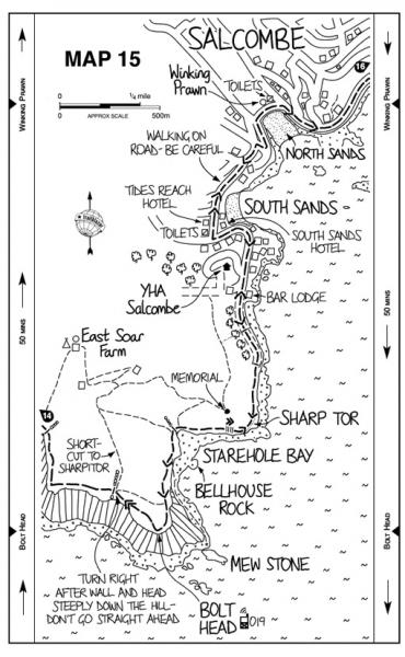
From Outer Hope the path meanders past seafront residences to its Siamese twin, Inner Hope, from where a wooded path once again leads you away from civilisation. This stretch from Inner Hope to Salcombe is book-ended by two promontories, Bolt Tail (Map 13) and Bolt Head (Map 15). Bolt Tail comes first, a lovely westerly-facing headland which the path contours round before describing a hairpin bend south-east through fields to Bolberry Down; the whole stretch, by the way, is owned by National Trust. Despite the car park here the path feels quite remote; though if you missed your chance for refreshments at Hope, there are a couple of picturesque alternatives near the path.
Port Light Inn (Map 13; Tel: 01548-561384, www.portlight.co.uk; 3T/4D or T; £38-57pp for B&B, £58-77pp for DB&B; sgl occ £76-102 B&B, £96-122 DB&B only; food served mid Feb to mid Nov noon-2pm & 7-8pm; school summer holidays 6.30-9pm) has accommodation but is probably of more use to trekkers as a place for lunch (sandwiches start at £4.95, rising to £7.25 for the Salcombe crab).
Further on (and about 1km off the trail), East Soar Farm (Map 15; Tel: 01548-561904, www.eastsoaroutdoorexperience.co.uk; £25 per stay) is an upmarket and innovative camping service where they supply a pre-pitched bell tent (there are six) with outdoor furniture, lanterns, and sleeping mats – and even bedding and half-board, if required, and all for £30pp (£25pp for breakfast only). They also offer indoor camping in the autumn/winter months. In addition, they have a bunkhouse (also £30pp) which sleeps up to eight people. Booking is essential for all accommodation and food cannot be prepared on site. They have also established a Walker’s Hut (open to anyone; summer daily 10am-6pm, winter weekends only and depending on the weather) from where they offer hot drinks, snacks and shelter.
The approach to Bolt Head is marked by increasingly severe gradients, ensuring that by the time you reach civilisation again, at the twin millionaire hamlets of South Sands (home to YHA Salcombe; see p128) and North Sands you’ll be ready for a drink again.
The very busy Winking Prawn (Map 15; Tel: 01548-842326, www.winkingprawn.co.uk; in the summer they are usually open daily 9am-9pm and in the winter Mon-Fri 10am-4pm, Sat & Sun 9am-9pm) can help you in terms of a drink and the food is good if a little expensive, with sandwiches and baguettes £6-7. Most people, however, will probably want to continue to Salcombe, where further options await...
Dorset & South Devon Coast Path (South-West Coast Path Part 3)
Excerpts:
- Contents
- Introduction
- How difficult is the path?
- Planning your walk
- Using this guide
- Sample route guide: Bigbury-on-Sea to Salcombe
Price: £13.99 buy online now…
Latest tweets