'Fantastically detailed and well-presented.'
— Backpack magazine
The Inca Trail, Cusco & Machu Picchu
Excerpt:
Sample route guide
Contents | Introduction | With a tour group or on your own? | Route options | Sample route guide | Food & drink
The classic Inca Trail
This is the undisputed draw for most people coming to Cusco and is by far the most popular and over-subscribed trek in the region. Given that you can get to Machu Picchu in four hours on a train, there has to be something intrinsically exciting and rewarding about the Inca Trail to merit spending four fairly grueling days walking to the same destination.
Passing through outstanding scenery, dramatic landscapes and encountering a series of increasingly spectacular ruins, it is in fact a spellbinding way to arrive at Machu Picchu and a walk that absolutely lives up to its billing as one of the finest in the world.
KM88 (QORIHUAYRACHINA) TO HUAYLLABAMBA MAP 1, p222
The train from Cusco only stops briefly at Km88, sometimes also referred to by its Quechua name Qorihuayrachina, so watch the kilometre markers after Km82 and be ready to disembark. Once off the train continue to walk west along the tracks, in the same direction as the train was heading. A path leads away from the tracks and down to the river, where there is a substantial bridge and a warden’s hut. A guard here will check your permit and passport before letting you cross the river and begin the trail proper.
Once on the far side of the bridge bear left (east) and climb gently through a stand of eucalyptus trees above the southern bank of the Urubamba.
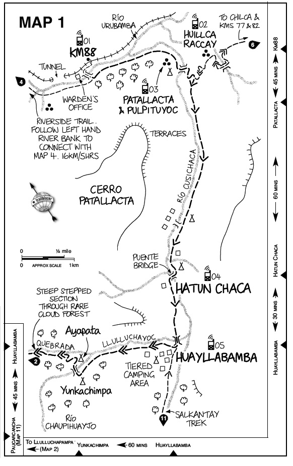 Three-quarters of an hour after setting off from the bridge you will come to the mouth of the Cusichaca Valley, down which flows a river by the same name. At the junction of the two valleys lie the sprawling ruins of Patallacta (see box below). A small round tower, Pulpituyoc, stands on a ridge by the river. It is possible to camp on the banks of the river in the lee of the ruins.
Passing to the east of Patallacta, the trail continues gently gaining height whilst continuing south before crossing over the Cusichaca and climbing steeply up the opposite slope for 10-15 minutes. It settles on the eastern bank and begins to head upstream towards Huayllabamba. In places the path divides briefly before coming together again. Follow the broader, most obviously used track (usually the lower branch) in these instances.
The path climbs gently but steadily for an hour, passing first beneath cliffs covered in bromeliads and then through gentler terrain. Several terraces are visible on the far side of the river. Ignore the lesser tracks leading down to the river, one of which crosses a bridge to a small settlement on the far, western bank. Stay on the eastern bank; is possible to camp on this side opposite the houses on the western bank. Continue past a signboard exaggerating the steepness of the route ahead and a hut where you can buy soft drinks. From this point there are good views back down the Cusichaca valley to Mt Verónica, which is visible as a pyramid in the middle of the valley.
Beyond the huts the path arrives at a second bridge (Puente). Cross the Cusichaca here and climb sharply to a small settlement called Hatun Chaca, where there are some flat pitches for a campsite; you can also buy soft drinks or chicha here.
Half an hour and 2km (1¼ miles) after Hatun Chaca cross another bridge, over the Llulluchayoc, a tributary of the Cusichaca, at the outskirts of Huayllabamba. Huayllabamba, a sprawling place built above Inca terraces, is the largest village on the trail and it’s the last place where you can buy basic food supplies. There are a number of campsites here with toilet blocks and cold running water. Huayllabamba used to have a reputation for theft but it is much improved and is one of the few sites along the trail where you can camp within a community, chat with locals and even join a game of football on the local pitch (though it is exhausting work at this altitude).
At the top of the village is a warden’s office where you must register and where porters have their loads checked and weighed before they can progress.
HUAYLLABAMBA TO PACAMAYO CAMP MAP 1; MAP 2
From the bridge over the Llulluchayoc follow the trail on the river’s left-hand (south-west) bank, heading uphill. At a hairpin bend it quickly gets much steeper; after about an hour of climbing you reach Yunkachimpa campsite alongside the Río Chaupihuayjo (also shown as the Río Huayruro on some maps). Small and set on two tiers, the campsite itself is OK, but the surrounding area is badly littered and has in places been used as an al fresco toilet by inconsiderate trekkers.
Pass through the campsite and over a bridge across the river. Then head steeply uphill through a clearing and small campsite called Ayapata, before following the left-hand (south-west) bank of Quebrada Llulluchayoc as it veers to the west. Lupins and snapdragons line the path and you soon enter a beautiful cloud forest or polylepsis woodland, rare in the Andes because it’s self-contained. The path climbs through the forest alongside the course of a river, occasionally close to the water and at other times high above it, on a series of steep steps.
As you reach the fringe of the forest there is another campsite, but 20 minutes beyond this, above the treeline, is a better one. Llulluchapampa has running water, a toilet block set on the top tier of terraces and exceptional views down the valley. It is exposed though and can get very cold at night; after torrential rain the ground becomes boggy here.
Beyond Llulluchapampa it is possible to make out the first pass. Abra de Huarmihuanusca (First Pass) is sometimes spelled Warmiwañusqa but is more commonly known as Dead Woman’s Pass. It isn’t known who the dead woman was or even if there was actually a dead woman at all, with many putting the name down to the fact that the pass resembles a woman lying on her back as if dead. The ascent to the pass looks deceptively simple. Although it is a gradual, steady climb parallel to the river, up to its source and then across the puna and over a section of paved path (laid in 1998 to protect the mountain from erosion), it will take 1½-2 hours to reach the high point (4200m/13,775ft).
From the broad saddle that marks the pass, the path descends steeply and swiftly into the neighbouring valley, plummeting 800m/2625ft in the course of just over a mile. At the bottom of this dizzying descent is Pacamayo campsite, a vast, sprawling campsite set amidst some scrubby trees, adjacent to the Río Pacamayo. It is popular with large tour groups and although the facilities here are reasonably good, with two toilet blocks, it is often noisy and crowded. Guides have to register at the warden’s hut in the centre of the site.
The Inca Trail, Cusco & Machu Picchu
Excerpts:
- Contents
- Introduction
- With a tour group or on your own?
- Route options
- Sample route guide
- Food & drink
Latest tweets