Practical guidebooks for the more adventurous traveller.
— The Herald
Preview an Excerpt
Thames Path: Thames Head to Woolwich (London)
(British Walking Guide)
by: Joel Newton & Anna Udagawa & William Allberry
Price: £12.99 BUY NOW
ISBN: 978-1-912716-27-2
3rd edition
272 pages
Paperback, sewn binding
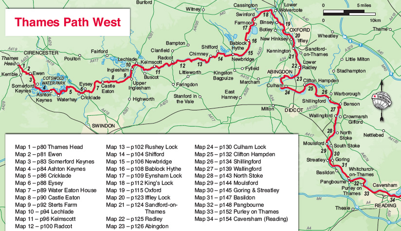
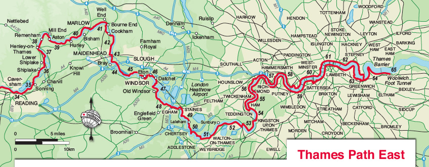
90 trail maps, 10 town plans, 14 full colour profile maps, 2 full colour overview maps
30 colour photos
120mm x 180mm 5" x 7"
- 'excellent guidebook'
- Strider, Long Distance Walkers Association - 'The detail is impressive.'
- Backpack - 'a thoroughly enjoyable companion to the trail.'
- Thames Guardian, River Thames Society - An excellent read.
- Backpack - All you need to walk the Thames Path
- Outdoor Enthusiast - invaluable
- Backpack - I was inspired by Joel's refreshing, and very British, attitude to the weather, the joy of pubs and walking itself, with a path that can be broken down into manageable segments.
- Round & About - With this book in your hand or tucked into your backsack you would have immense difficulty in getting lost or not knowing where the nearest restaurant, pub or bus route is.
- River Thames News - Everything you could possibly need to know - and perhaps a little bit more besides;
- Waterways World - Another polished and comprehensive Trailblazer title
- Walk magazine online - this volume will add much to your enjoyment.
- Backpack - practical, clear-eyed and enthusiastic
- Wanderlust - a fascinating guide to what you'll find in any given section of the "path".
- Books Monthly - Recommended.
- Adventure Travel
The Thames Path is a national trail running for 185 miles from the river’s source at Thames Head near Kemble to Woolwich in London.
The path begins, as the river does, in a meadow in the Cotswolds; its upper reaches lonely and wild. As the waters deepen the settlements along its banks begin to grow in both size and grandeur and, reaching Oxford, the solitude of the river slowly subsides and the trail becomes as much about historic towns, churches, abbeys and castles as it does the river.
Lechlade, Abingdon, Wallingford, Henley ... they all owe their location to the Thames, and different eras, when the river was a life source, a place of conflict, a boundary, a mode of transport and the provider of leisure, which, thankfully – for us, at least – it remains to this day.
Squeezing through the ancient Goring Gap, loomed over by the Chiltern Hills, you pass Runnymede, the site of the signing of Magna Carta, and Windsor Castle. Passing by so many ancient sites, this is as much a walk through history as an easy ramblealong a river bank.
The route through London – particularly along the south bank – remains relatively countrified, at least as far as Putney, from which the approaching sights of Westminster and Tower Bridge offer vistas as impressive as any others along the river’s green and scenic upper reaches.
Leaving central London, the regenerated docklandareas of East London lure you to your journey’s end, now just past the Thames Barrier at Woolwich and the conclusion of a most enjoyable and magnificently-varied riparian ramble, quite unlike any other in Britain.
Features
1. Classic Trailblazer style – In many walking guides the reader has to read a route description then try to relate it to the map. Our guides are easier to use because walking directions, tricky junctions, places to stay and eat, points of interest and walking times are all written onto the maps themselves in the places to which they apply.
With their uncluttered clarity, these are not general-purpose maps but fully-edited maps drawn by walkers for walkers. Downloadable GPS waypoints also included.
2. The largest scale walking maps available – At just under 1:20,000 (8cm or 31/8 inches to 1 mile) our maps are bigger than even the most detailed walking maps currently available in the shops. Redrawn for this third edition in our new two-colour style.
3. An all-in-one guide – Trailblazer guides include practical information not usually found in walking guides to the UK: reviews of places to stay, places to eat, attractions along the way and detailed public transport information showing all access points on the path, for weekend and day walkers.
Updates:
Latest Updates for Thames Path: Thames Head to Woolwich (London)
Price: £12.99 buy online now…
Latest tweets