These Trailblazer guides … are a godsend for independent travelers.
— Travel & Leisure
Trekking in the Everest Region
Excerpt:
Sample trek
Contents List | Introduction | Planning your trek | Facilities for the trekker | Sample trek | Minimum impact trekking
 JIRI TO NAMCHE
Introduction
Jiri to Namche takes most people seven to nine pleasant days’ walking, usually including a rest day at Junbesi and a shorter easy day or two. If you have more time and energy there are plenty of opportunities for side trips exploring little-visited villages and gompas.
Several alpine valleys are also worth more thorough exploration by well-equipped parties. For the extremely fit in a hurry, walking from Jiri to Namche in four days is possible – just.
There are good lodges along the main route and since these are usually only a few hours apart it's not necessary to plan a detailed itinerary. Simply follow your instincts and the advice of other trekkers rather than sticking to a rigid schedule.
The walk is strenuous, following a route that goes against the grain of the land: all the rivers and ridges flow north to south and the trail runs west to east.
You cross an unnamed 2700m/8858ft pass, the Lamjura Pass 3530m/11,581ft and Trakshindo Pass 3071m/10,075ft. Once across the Dudh Kosi (river), the trail climbs high up the valley sides skirting steep rockfaces before descending to recross the river several times before the final hill to Namche.
Following the standard route (not including side trips) by the time you reach Namche you will have climbed up almost exactly the height of Mt Everest, 8848m/ 29,028ft, and the corresponding descents to Namche total the height of Ama Dablam, 6828m/22,402ft.
Since you have trekked the majority of the time between 2000 and 3000m this means you are well acclimatized to around 3000m and unlikely to feel the altitude at Namche. However, higher up you should take it just as cautiously as everyone else.
Jiri has been the end of the road into the hills in this region for more than 15 years. Now, however, the road is being extended, though it is unlikely to be completed particularly quickly.
Currently sections are being built as far in as Bhandar but it is only driveable as far as Shivalaya. Some buses finish there, others at Jiri and with a local service going the rest of the short distance.
Services
With the whole country in decline, facilities tend to be basic. For medical facilities ask local advice. Phaplu has a bush hospital, and there could be doctors at Jiri and perhaps Kharikhola.
Between Jiri and Lukla there are no functioning banks. Jiri and Phaplu have phone services, then Lukla. The hill phones are normally CDMA, rather than the more common GSM systems.
Kathmandu to Jiri
From the old bus station in the centre of Kathmandu the first departure for Jiri/ Shivalaya is at around 5.30am. Thieves sometimes work the bus station and this route so take great care of your luggage.
There are also occasional pickpockets at the bus station. Their favourite trick is to watch where you put your change after buying your ticket then hurry you onto the bus while their hand delves into your pocket. The police have been unhelpful in all cases.
The first part of this 10- to 12- (and occasionally up to 16-) hour bus journey is to Lamosangu (78km, 5 hours) along the Chinese-constructed Arniko Rajmarg or Kodari Highway that runs to the Tibetan border and Lhasa.
Leaving Kathmandu you pass through the lower part of Bhaktapur, then Banepa where, until the early 1960s, the expeditions to Everest began.
There is a steep climb out of the Kathmandu Valley and from Dhulikhel, at the crest of the hill, there are views on a clear day of the Himalaya from Manaslu to Everest.
The road drops to Dolalghat (ghat means ‘bridge�) and crosses the Indrawati River. The Chinese road had progressed this far by 1967 so the first commercial treks to the Khumbu started from here.
After crossing the Sun Kosi (�Gold River�) the road follows the river to Lamosangu (�Long Bridge�), the buses usually stopping by the scruffy stalls by the bridge for dal bhaat.
From the bridge it's a further 110km to Jiri, marked by kilometre posts that start at 0km from Lamosangu bridge. This road was part of a Swiss aid programme, constructed as a model to demonstrate building techniques for mountain roads using appropriate technology.
Rather than employing expensive machinery it was decided to maximize the use of local labour. Rocks were broken with hammers and a lot of sweat, and all the wire netting was woven by hand, providing a vast amount of work.
In addition to wages, food was sold in set quantities at subsidized prices to reduce the local impact of the hungry workforce.
The only heavy machinery used was a road roller. The result is a Swiss-quality road that has lasted longer with less maintenance than any other road in Nepal. Unfortunately, the technique and attention to detail hasn't been duplicated for the rest of Nepal's rural hill roads.
From Lamosangu it can be pleasant to ride on the roof of the bus (theoretically illegal) but take a jacket or wind-cheater. At the top of the first major ridge is Muldi where there may be another stop before continuing to Charikot (at the km54 marker).
The turn-off to the left here leads to Dolakha (see p269), a few kilometres away. On a cloudless day the monumental twin-headed Gauri Sankar stands out for the next half-hour. The high peak slightly to the right is Menglutse in Tibet.
The descent to the Tamba Kosi (�Copper River�) is steep. At the bridge the driver takes a break for a cup of tea or two. If you are on the roof it's a good idea to start putting on warm clothes because it is still several hours and 38km to Jiri.
The plantations you pass are a Swiss reforestation programme.
After another pass the gradual descent to Jiri begins and at a stop at Kot you might have to register at the police checkpost. Jiri is ten minutes further on, and Shivalaya a rough hour or so.
Note that in winter it's not unknown for a snowfall or sheet ice to block a high section of the road, which means a couple of extra days’ walking.
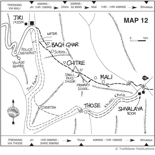
JIRI TO SHIVALAYA [Map 12]
Jiri (1935m/6348ft)
Nestling in a fertile valley and beyond the ugly materialism of the road, Jiri is a prosperous and tidy village. The people are mainly of the Jirel caste who originate, so the legend goes, from a Sherpa mother and a Sunuwar father.
There are also some Sherpas and with the road (which linked Jiri in 1984) came the merchant castes, mainly Newars. There are many lodges now mainly used by locals.
If you do end up trekking ask Jiri locals where the trail starts. It climbs to Chitre then further over a small pass before dropping to Mali then more steeply to a fine suspension bridge to Shivalaya.
Shivalaya
The good tar-sealed road ends and it is a rough and dusty ride to Shivalaya. This once sleepy village is now booming: there are a handful of lodges, all simple, and in most cases it will be safest to order dal bhaat (see box below) or noodles. The small shops here are packed with cheap goods and supplies.
Trekking in the Everest Region
Excerpts:
- Contents List
- Introduction
- Planning your trek
- Facilities for the trekker
- Sample trek
- Minimum impact trekking
Price: £15.99 buy online now…
Latest tweets