'Fantastically detailed and well-presented.'
— Backpack magazine
Trekking in the Pyrenees
Excerpt:
Introduction
Contents List | Introduction | Route options | Planning your trek | Eating and Drinking - Pyrenean Style | Sample Trek
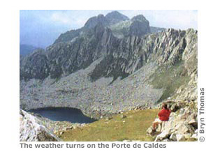
From the rolling foothills of the Basque Country to the bare rocky peaks of the Maladetta Massif, the Pyrenees have something for everyone. Deep green valleys characterize the western end of the range, while dusty brown slopes speckled with vineyards are distinctive in the east. The harsh, empty landscape of the Central Pyrenees can be forbidding and beautiful by turns, with its passes, gorges, caverns and waterfalls.
The Pyrenees offer all that's best in walking: fantastic scenery, great places to stay, good weather and, above all, variety. Serious trekkers will relish the chance to seek out the untouched valleys of the high mountains. Those who prefer an easier pace can stay closer to civilization, enjoying the culture of the area through which they are walking. The region can provide the best of both worlds. Stay high in the mountains for days on end if you like, either camping or using the excellent mountain refuges that are available on both sides of the border. When you decide to venture down, the hills are scattered with beautiful villages, ideal places for an overnight stop. Try the local wine and cuisine, relax and regain strength for the next day on the trail.
There's a wide variety of other activities, too. If you like to break the day's trek for an hour or two, there are literally hundreds of perfect lakes in which to cool your feet or, if you're hardy enough, to swim. The clear mountain tarns are ideal for a day's fishing, and the ancient churches are worth a visit in their own right. For the adventurous there's everything from mountain biking and paragliding to rafting and rock climbing.
Traditionally the Pyrenees have been compared to their nearest neighbours, the Alps, and because of their inferior height have somehow remained off the walker's ‘wish’ list. The result is an area of mountains which has, for the most part, escaped the commercialization that has occurred elsewhere; a place where there is still scope to explore an area of untouched natural beauty.
USING THIS GUIDE
In this guide the region is split into three sections: Western, Central and Eastern Pyrenees. The introductory chapters cover getting to the mountains and what to expect when you get there. Thereafter, the information about each area is to be found at the start of the appropriate section. If, for example, you are planning to go to the Basque country (Western Pyrenees) you will find information on trains, planes and buses in Part 1. Information about local bus services once you arrive is to be found at the beginning of the section itself or in the relevant village section in the trail guide.
Trail maps
The sketch maps in this book are designed to be used in conjunction with large-scale contour maps, not to replace them. The maps are drawn to make route planning easier by showing the detail which other maps do not: walking times, accommodation, viewing areas, water points, difficult route junctions and other useful observations. Everywhere to stay that is within easy reach of the trail is marked – be it a top hotel or an empty shack. Further details about each place can be found in the text.
Routes and walking times
The routes are described from west to east, the direction in which most walkers tend to tackle longer treks through the Pyrenees. A good reason to follow the trend if you're walking the GR10 is that it involves a long uphill stretch on most mornings and with an early start you can complete much of it in the shade. If you plan to walk from east to west allow for the fact that the timings on the maps may vary slightly in the opposite direction.
Note that the time given along the side of the map refers only to the time spent walking, so you will need to add 30-40% to allow for rest stops. Remember that these are my timings for the section; every walker has his or her own speed. With the earlier editions of this book, several readers commented that they found these timings on the fast side. The times are, however, consistent so you should err on the side of caution for a day or two until you see how your speed relates to my timings on the maps. When planning the day's trekking, count on between five and seven hours actual walking, and allow for an occasional rest day.
Trail profiles
At the start of each section we've included a simple route profile showing altitude for the main places on the corresponding map and the time taken to reach them. As noted above, times are walking times only and you should add 30-40% to allow for rest stops.
Latest tweets