Guides that will send you packing.
— Today
Nepal Trekking and The Great Himalaya Trail
Excerpt:
Kanchenjunga region
Contents | Introduction | Planning your trek: trekking styles | Route Guide: main trekking areas | Kanchenjunga region
Kanchenjunga region
Lush rhododendron forests, dramatic mountain vistas, communities that abound in folklore and the third highest peak in the world, Mt Kanchenjunga, all combine to make this a paradise for trekking off the beaten path.
Located in far-eastern Nepal, on the border with Sikkim, Kanchenjunga Conservation Area (KCA) was one of the first areas of the Himalaya to be explored in the 19th century, and yet it remains largely unvisited by tourists outside of October.
The Nepal side of the Kanchenjunga massif is split into three distinctive trekking regions:
• The north face to Kanchenjunga Base Camp – described in detail on p117.
• The remote valleys that lie beneath the horseshoe-shaped south-west face and ridges, around Yalung (summary only; see p122).
• The pahar trails that lead north–south and east–west through the regional hub of Taplejung.
Along the higher trails, communities are isolated from the lower valleys by a maze of ridges and peaks. So, treks to this region are a little longer than those to the most popular areas, but spending a little extra time here will prove more than worthwhile as you get to explore one of the wilder corners of the Himalaya.
Most trekkers arrive at Taplejung (by road via Ilam or the Suketar airstrip), which attracts a lively combination of Sherpa, Limbu, Rai and Gurung people, especially for the Saturday market. However, if you are trekking to Phalut, on the border with India, your trek will begin from the jeep road-head at Chyangthapu (Phunlading).
Note that you will need a special permit from the police station here to trek to the border and stay at or near Phalut.
The KCA is the first region in Nepal to be managed by local communities and this has so far proved very successful along the main trail, but is yet to be fully effective in remoter valleys. Trekking is still in its infancy in much of the KCA so tread lightly and encourage sustainable practices wherever you can.
As at March 2014, the trekking permit fee for the Taplejung District/ Kanchenjanga Region (includes Olangchung Gola, Lelep, Papung and Yamphudin) is US$10 per person (pp) per week. Plus the Kanchenjunga National Park entry fee of Rs2000pp.

KANCHENJUNGA BASE CAMP TREK
The return trek to Kanchenjunga Base Camp takes about 20 days and can be combined with a number of trails to explore some magnificent wilderness areas. If you want to visit the southern valleys of Kanchenjunga, combine trails to Yalung via Ghunsa and Yamphudin.
Another great option is over Nango La from Ghunsa to the intriguing communities of Olangchun Gola and Yangma, from where you can explore some really remote mountains.
There are two main seasons (April-May and October-November) for visiting Kanchenjunga; both offer very different trekking experiences. Being isolated from the other main ranges in Far East Nepal, Kanchenjunga is renowned for making its own weather and suffering from heavy monsoonal rains.
After the monsoon has finished the mountains are free of lingering cloud and the views in late October and November are probably at their best. By mid-December snow closes the higher trails, which will not open again until mid to late February at the earliest.
The pre-monsoon period is famous for the stunning forests of rhododendron that begin at Suketar and continue throughout the trek, and are perhaps the most extensive throughout the Nepal Himalaya.
Getting to and from the Kanchenjunga region can be time consuming. In the main trekking seasons a scheduled flight operates between Biratnagar and Suketar a few times a week. For the remainder of the year, you either have to drive to Taplejung or Phidim, or charter a helicopter to Suketar.
DAY 1: KATHMANDU–TAPLEJUNG/SUKETAR 2HRS
The only scheduled flights to Suketar (2420m) from Kathmandu are on Sunday and Wednesday (Tara Air), for the rest of the week you either have to fly via Biratnagar (causing an overnight delay), or charter your own flight, or use a combination of flight and bus to the large Limbu settlement of Taplejung (1820m). Flights can be delayed due to bad weather so it is wise to organise a second option, just in case. If you arrive late in the day at Suketar there are some simple teahouses next to the airport, alternatively it is an easy downhill walk for two hours to Taplejung.
DAY 2: SUKETAR/TAPLEJUNG–PHURUMBU 4HRS
Suketar sits within a web of trails that can easily confuse, so make sure you walk with your guide or ask locals for directions at trail junctions. From the airstrip follow a grass-covered trail northwards for 20-30 minutes which brings you to a major trail junction where you turn right; ask for Bhotegaon if you are confused.
The trail slowly descends providing views of the Tamor Khola valley below to your left. This is a very fertile region with three crops being produced per year; depending on the season and altitude it might be rice, millet, corn, potatoes, cauliflowers or green vegetables that surround you.
Slowly curving northwards the trail moves on to a spur that suddenly steepens at Gadidanda (1890m, 2½hrs).
The 350m descent is on a hard-earth trail that is slippery when wet, so take care. There is a good camping site in the school at Phurumbu (1542m, 1hr) to the left of the trail just before the steep section is finished.
DAY 3: PHURUMBU–CHIRUWA 6HRS
The trail dips and climbs slightly as you pass a stream, and then again after Baishakhe (sometimes also called Moyam; 1520m, 1hr). Now the descent towards the Tamor Khola continues, first to Linkhim (1300m), then Tawa (1120m, 1hr) before finally reaching the valley floor before Nagadin (1050m, 4hrs).
The villages you pass through are part of a historically important region in Nepal; this is where the Kirati warriors came from who first tried to unite the many kingdoms of the Himalaya into a single sovereign state.
The trail climbs slightly as you approach Chiruwa (1270m, 40 mins), a compact settlement of teahouses, shops and school, all squeezed between the river and steep hillside. The school sportsground, which doubles as a campsite, is 10 minutes further on and off the main trail to your left.
DAY 4: CHIRUWA–SUKATHUM 5½hrs
After the heat of the previous afternoon it’s a relief to start walking in the cool morning air from Chiruwa. The main trail remains on the river’s south bank and if you get an early start you won’t need to walk in the sun until just before the National Park checkpost at Taplechok (1380m, 1¾hrs).
It is necessary to stop and complete formalities with the National Park staff, perhaps over a cup of tea, and confirm if there are any landslides ahead, which might mean taking an alternative trail.
From Taplechok, the main trail crosses a long suspension bridge to the west bank (true right) trail. You first wind through cardamom fields and then into dense forest before gradually climbing away from the Tamor Khola to Lelep (1750m, 3hrs) which has a small teahouse.
A trail descends rapidly from Lelep to a suspension bridge across the Tamor Khola to Sukathum (1576m, 40 mins) and a large campsite.
The old route, only used if the main trail is broken, takes the east bank (true left) trail and follows the river before climbing a little after Tamewa (1420m, 2hrs), then down to Simbuwa Khola at Hellok (1550m, 1hr) where there is a small teahouse.
A trail winds around to the Ghunsa Khola valley and across a suspension bridge to Sukathum (1576m, 30 mins) and the campsite.
DAY 5: SUKATHUM–AMJILOSA 6HRS
This is the toughest and most dramatic day of the trek so far. Cross the suspension bridge at the Sukathum campsite to the true left bank of the Ghunsa Khola, and follow a trail through dense forest until the valley narrows into a deep gorge (2hrs).
Waterfalls cascade down both sides of the valley; the sound of the river will make conversation difficult. It is essential you concentrate on the trail. Locals have built a stone walkway beneath a cliff-face along the river’s waterline, which makes for some great pictures but care is needed at all times.
After negotiating this section, there is another hour of dense forest trail before you cross a bridge at the base of a steep climb. Switchbacks ascend 350m (2hrs) before the gradient eases, about one hour before Amjilosa (2308m).
DAY 6: AMJILOSA–GYABLA (KYAPRA) 5HRS
The trail leaving Amjilosa wastes no time in climbing a minor ridge to a sharp turn to the north (30 mins). The forest is dense and dark as you again descend towards the Ghunsa Khola at Thyanyani (2405m, 1hr) and the first of a few slippery log bridges across streams.
There are a few small stone shelters here which are normally only used by herders in monsoon.
For the first time in a number of days the trail doesn’t seem to continually climb up and down, as the valley widens slightly and feels less claustrophobic. After the third bridge (2hrs) the trail climbs another steep track for roughly 300m (2hrs), the last section beside a stream can be slippery so care is needed.
You crest the climb and find yourself on the outskirts of the picturesque village of Gyabla (Kyapra, 2730m). For those with time and energy there is a pleasant walk up behind the village with views of the Birdhungga Danda.
DAY 7: GYABLA (KYAPRA)–GHUNSA 4½HRS
After the previous week this day marks a noticeable change in the flora and fauna along the trail. At first, the trail seems much like that of the previous afternoon; a broader valley bottom permits views of the river and hillsides, which continue for 1½ hours.
Then the trail climbs for 200m (1hr) and suddenly you notice rhododendron, camellias and azaleas rather than bamboo and cardamom beside the trail. The village of Phale (Phere, 3140m) is spread over a large area. The first houses are the winter village for Ghunsa, before the village proper (30 mins).
This is a Tibetan refugee settlement where it’s possible to buy handicrafts and homemade rugs from some of the locals, ask around when you arrive and potential sellers will soon find you!
From Phale a pretty trail winds through dwarf conifer and pine forest before crossing a suspension bridge (to the true left bank) and arriving at Ghunsa (3595m, 1½hrs) in a broad section of valley.
Waterfalls fall from the steep cliffs above this Sherpa village that feels like the edge of nowhere on a cloudy day.
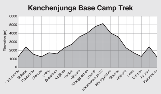
DAY 8: GHUNSA ALL DAY
As you have now passed the 3000m mark, it is wise to take an acclimatisation rest day at Ghunsa. You can relax and explore the village.
Sherpa hospitality is legendary and the local school is proud to show off its computer (you can charge iPods here for a donation).
Alternatively, explore the Yamtari Khola which boasts a fantastic view of Jannu (7711m) from the south – first follow the water pipe for the village hydro-generator and climb on the true right side of the river until you reach some herders’ huts, then cross boulders to reach the viewpoint.
This valley is also the route to the disused and dangerous Lapsang La (5161m), as well as Sele La (4290m) and Sinion La (4440m) both of which offer interesting route variations to/from Yalung if you have camping gear (see Other Trails in the Kanchenjunga Region, opposite).
DAY 9: GHUNSA–KHANGPACHEN (KHAMBACHEN) 5½HRS
Deodar pine and rhododendron forest, grassy glades dotted with wild flowers, and increasingly spectacular mountain scenery combine into what is perhaps the most impressive section of trail along the entire trek.
It will take about 1½ hours to reach a bridge that crosses to the true right bank of the Ghunsa Khola and Rampuk Kharka (3720m). Note that the bridge is often blocked with sticks to prevent yaks from wandering.
The trail now climbs almost 400m past, and then through, a large landslide (beware of rockfall) beside the terminal moraine of the Kanchenjunga Glacier to 4100m (2½hrs).
A brief traverse of the hillside offers a good view of Jannu before descending to the yak farming settlement of Khangpachen (Khambachen, 4050m, 1½hrs).
DAY 10: KHANGPACHEN (KHAMBACHEN) ALL DAY
A day to acclimatise is normally taken at Khangpachen (Khambachen), where there are two great day walks to help you adjust to the 700m altitude gain tomorrow.
One route is to explore the valley directly behind Khangpachen and walk up to the base of Tha Nagphu (5980m), a massive snow and rock dome that you can see from the village.
Alternatively, for those feeling fit, cross the river and climb the true right (left-hand) side of the Kumbhakarna Glacier lateral moraine to the popular pilgrimage site beneath the massive vertical north face of Jannu – there is a large boulder and plenty of prayer flags to mark a viewpoint.
DAY 11: KHANGPACHEN (KHAMBACHEN)–LHONAK 5HRS
The trail away from Khangpachen is surprisingly easy as you gradually climb scrubby lateral moraine for one hour. Then comes perhaps the hardest and most dangerous section of the entire trek, a climb up a long section of landslide, mostly across large boulders, which takes about 2½ hours.
It is wise to keep moving, however slowly, across this section and complete the climb as early as possible as the risk of rockfall increases throughout the day.
Once across the stream from the waterfall section the trail climbs steeply (beware of rockfall) for a short section to the top of an ancient lateral moraine at 4670m (a popular lunch stop), where the gradient eases as you cross some scrubby and grass-covered moraine.
On the far side is the Lhonak Khola, which you follow to a seasonal bridge and a few stone shelters at Lhonak (4780m, 2hrs).
DAY 12: LHONAK ALL DAY
The large sandy bed of the Lhonak Khola offers an inviting walk for an acclimatisation trip. It is important that you are prepared for and understand the hazards of river crossings if you want to fully explore this valley.
It is possible to explore a rough track along the western edge of the Lhonak glacier to the confluence of the Chabuk and Chijima glaciers at 5080m, 5 hours’ return.
Alternatively, you can enjoy the views of Gimmigela, Wedge Peak, Nepal Peak and Tent Peak (Tharpu Chuli) that line and head the valley to the east. Try to spot the rock pinnacle on the far side of the glacier, just at the point it turns south-west.
DAY 13: LHONAK–KANCHENJUNGA BASE CAMP 4HRS
The trail from Lhonak climbs gently along the massive lateral moraine of the Kanchenjunga glacier for the first 2 hours. It’s hard not to stop and admire the views of the peaks and the glacier below.
A short steep section of loose rock and landslide formed by a side river will take 40-60 minutes to cross. The trail then climbs more gently for another hour before you reach the few stone huts of Pangpema and Kanchenjunga Base Camp (5143m).
Expedition groups will probably not have a permanent camp here as an advanced base camp across the glacier has become a preferred spot.
DAYS 14-21
Return to Suketar along same route, then fly to Kathmandu.
Nepal Trekking and The Great Himalaya Trail
Excerpts:
- Contents
- Introduction
- Planning your trek: trekking styles
- Route Guide: main trekking areas
- Kanchenjunga region
Price: £15.99 buy online now…
Latest tweets