'These human-scale books, written and published by people who genuinely know and love their subject, are perfect for travel's post-pandemic recovery.'
— The Guardian, March 2021

Cotswold Way: Chipping Campden to Bath
Excerpt:
About the Cotswold Way
Contents | Introduction | About the Cotswold Way | Planning your walk | Using this guide | Sample route guide: Birdlip to Painswick | Stage Map and Trail Profile sample
HISTORY OF THE TRAIL
The Cotswold Way runs for 102 miles (163km) through the Cotswold Hills from Chipping Campden in the north to the Georgian city of Bath. The route was originally devised as a long-distance footpath by members of the Ramblers’ Association and was established in conjunction with the Cotswolds AONB in 1970.
Its development as a national trail was approved in 1998, but it was not until May 2007 that the trail was formally launched, one of just 15 in England and Wales. During the transition, several changes were made to the route, and others are still in the offing, although for the most part the original paths remain open.
The path is the responsibility of the National Trail Officer, under the auspices of the Cotswold Way National Trail Office (see box p42).
GEOLOGY
Look at a geological map of England and it is immediately clear that the origins of the present-day Cotswolds lie in the Jurassic period. Such maps show a continuous swathe of Jurassic-age rocks, formed between 199 and 145 million years ago, extending all the way from Dorset to the Yorkshire coast, with the most complete and impressive outcrop making up the Cotswold Hills.
Cotswold stone is an oolitic limestone, a sedimentary rock that was formed primarily in the warm shallow seas of the Jurassic. It is comprised of a large number of almost spherical granules, or oolites, packed closely together, and its origins explain the regular occurrence in the rock of fossils, such as sea urchins. Occasional falls in sea level, however, resulted in dry land where dinosaurs roamed, leaving behind both their footprints and their bones. While most walkers will see little difference between the rocks at various places along the trail, to the geologist there are marked distinctions according to the stages at which the sediments were deposited and compressed. In addition, while the surface rock of the Cotswold range is predominantly limestone, the underlying structure is more usually of clays, silts and sands. It is the precise structure of these rocks that both determines the wildlife that populates the hillside and influences the buildings you will see in each part of the region.
Gloucestershire Geology Trust (www.glosgeotrust.org.uk) is committed to studying and conserving the region’s geological heritage, and to recording regionally important geological sites. The trust publishes a series of trail guides (£2 each) entitled Gloucestershire Uncovered, which include Cleeve Hill Common, Leckhampton Hill and Crickley Hill.
HOW DIFFICULT IS THE PATH?
Familiarity with the Cotswolds – or at least with the tourist areas in the north – might lead to a sense that the Cotswold Way is little more than a walk in the park. While it would be unreasonable to suggest that it is seriously challenging, it would be equally wrong to underestimate the quite literal ups and downs of a route that takes you from just above sea level to 1066ft (325m) and back over a distance of around 100 miles.
If, as is often suggested, you plan to complete the route in seven days, you’re looking at an average of nearly 15 miles, or six to seven hours’ actual walking, every day. Some of those hills are steeper than you might expect from a casual glance at the landscape and poor weather can exacerbate what would otherwise be fairly straightforward. It makes sense, then, to have a reasonable level of fitness before you set off, if only to make sure that what should be an enjoyable week or so’s walking doesn’t turn into a test of endurance.
HOW LONG DO YOU NEED?
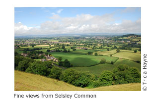
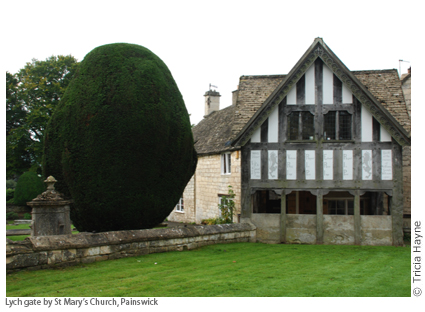
This is the great imponderable. Is it reasonable – as many hikers do – to walk the path from end to end in a week? Well yes, but it’s a qualified yes. If you have just seven days’ holiday but need two of those to get to and from the trail, you’ll be faced with walking 20 miles a day, which isn’t for the faint hearted. If, on the other hand, you can spend most of those seven days on the trail, a week is realistic. That said, averaging almost 15 miles a day won’t leave much time for exploring the villages on the route, taking time out for a cream tea in Broadway, or a pint of Donnington’s at The Mount Inn in Stanton, or exploring Selsley Common for orchids. You might find yourself casting a wistful backward glance at old churches as you march purposefully past the lych gate, or promising yourself you’ll come back to do justice to Hailes Abbey, or Dyrham Park, or even to Bath. So while the world reckons that this is a week’s walk, give it eight days and you’ll be adding in time to breathe.
If time is really short, you could reasonably leave out the last section, perhaps south of Cold Ashton and down Lansdown Hill into Bath (pp36-8). That isn’t to say this isn’t worthy of walking – far from it. But Bath is a destination in its own right, so the chances are that you could justify returning on another occasion.
Plenty of people can’t spare the time to walk from end to end in one go, but still get that sense of achievement by building up the miles over a series of day or weekend walks until they’ve completed the route. Alternatively, you could simply sample the highlights (though lowlights are few); see p33 for some recommendations.
Cotswold Way: Chipping Campden to Bath
Excerpts:
- Contents
- Introduction
- About the Cotswold Way
- Planning your walk
- Using this guide
- Sample route guide: Birdlip to Painswick
- Stage Map and Trail Profile sample
Price: £14.99 buy online now…
Latest tweets