Trailblazer guidebooks provide practical information on specific routes in less accessible parts of the world.
— Wanderlust

Peru's Cordilleras Blanca & Huayhuash - The Hiking & Biking Guide
Excerpt:
Hiking sample
Contents | Introduction | Itineraries | Minimum Impact | Hiking sample | Cycle Touring sample
NORTHERN CORDILLERA BLANCA
ALPAMAYO BASECAMP
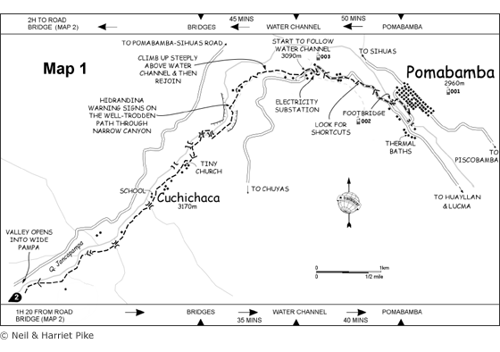
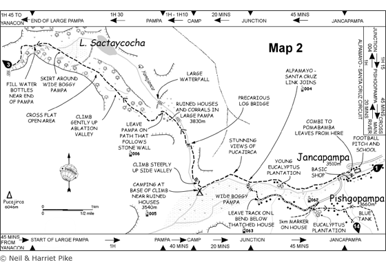
Day 1: Pomabamba – Jancapampa camp [Maps 1 & 2]
Duration 4h30-5h
Summary
Begin with an easy walk up to a camp on Jancapampa meadow which is towered over by Pucajirca’s mammoth glaciers. Most of this first day can be bypassed by catching transport to the village of Jancapampa, and walking up to the camp from there.
Leave Pomabamba’s Plaza de Armas at the NW corner on Jr Peru, before descending on steps to the main road. Turn R and soon take a path down to the Río Pomabamba, crossing on a footbridge then climbing to the Chuyas road (20 minutes).
Go R, following the road or footpath shortcuts. After passing an electricity substation and a ‘Pomabamba – Chuyas’ road sign, leave the road (30 minutes), descending R/N for a few metres to a water channel. Follow the channel into green, wooded Quebrada Jancapampa.
Despite Hidrandina disclaimers about not walking next to the channel, it’s a good path and the main one used by locals. The quebrada becomes narrow, with near-vertical walls, and after 45 minutes the channel meets the main river, crossing on a bridge to the N bank.

Soon recross and continue upriver on the eucalyptus-shaded main path, through small villages where children (and some adults) will ask you for caramelos. One hour and 45 minutes from the bridges, the path emerges onto the meadow of Jancapampa – continue for 15 minutes to reach the road bridge in Jancapampa village.
Cross the bridge, and take the shortcut that leaves the road at the first bend. When this rejoins the road soon after, go straight over onto a footpath that heads up valley, contouring high above the river on the N side. After 45 minutes the path descends to the pampa.
Ignore a small bridge to the L/S – this is the way to Tupatupa (see Santa Cruz Alpamayo link) – continuing instead up valley. The path fizzles out, but reforms, skirting above the boggy pampa.
Follow it along the straight-sided N shore of the pampa for 20 minutes until the pampa edge curves round to the L/S. There’s good camping here, level with the last houses on the opposite, southern, side.

Peru's Cordilleras Blanca & Huayhuash - The Hiking & Biking Guide
Excerpts:
- Contents
- Introduction
- Itineraries
- Minimum Impact
- Hiking sample
- Cycle Touring sample
Price: £17.99 buy online now…
Latest tweets