'Fantastically detailed and well-presented.'
— Backpack magazine
Trekking in the Annapurna Region
Excerpt:
Sample route
Contents List | Introduction | With a group or independently? | When to go | Minimum impact trekking | Sample route
SAMPLE ROUTE
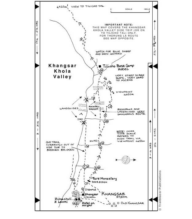
Khangsar (3730m) [see map p224]
If the hustle and bustle of Manang is getting to you then escape for a night to this undeveloped village, just a one and a half hour walk away. There are two new hotels here, of which the Hotel On Height has been recommended. There is a small shop where you can buy a few supplies. From the village there are superb views up the Khangsar Khola to Tilicho Peak (7132m/23,399ft) and the Grande Barri�re (so named by Herzog in 1950). A trip up this beautiful valley is a great aid to acclimatization. There's a small plain temple in the village and beyond Khangsar is Ta-hrap Gompa, built by the lama of Braga several hundred years ago.
Side trip around the Khangsar Khola valley, or on to Tilicho Tal
Maurice Herzog may have nipped up to Tilicho Tal from Manang alone with nothing more than a bar of chocolate but, having fallen in the river and spent the night in the open, he did almost die.
you'll need a sleeping bag and mat, though there are lodges at both Khangsar and at the head of the valley leading to Tilicho Tal. A round trip from Manang to the lake takes about three days, though it is common practice now to go straight from Khangsar to Yak Kharka on your return from the lake.
Although the paths have improved, the difficulties of a trip up this valley should not be underestimated – there are still several precipitous sections where steady feet and a cool head are required.
Routes Reach Khangsar in one and a half to two hours from Manang; you can also go straight from Braga to the bridges along a riverside trail that bypasses Manang altogether. The old trail along the southern side of the Khangsar Khola is now considered to be very dangerous because of landslides, and you are strongly advised to take the north bank trail, where you soon come upon two bridges across the Khone Khola. The newer, higher suspension bridge leads onto a path heading directly to Khangsar; the old bridge down below leads to the ruins of an old fort.
From Khangsar there are a couple of options for trips up the Khangsar Khola Valley. For those with only a day to spare, a long and strenuous acclimatization trip can be made around the valley, climbing to a high point of 4800m with stunning close-up views of Tilicho Peak and the Grande Barri�re. If you've got more time you could include an overnight stop in the hut at the head of the valley and then climb the long, steep trail to the small plateau overlooking Tilicho Tal, before returning. Under snow, however, the route to the lake becomes a serious mountaineering proposition with the risk of avalanche being high.
There are two main trails from Khangsar to the hut at the head of the valley. If you are planning on staying at the Tilicho Base Camp Hotel, ask first in Khangsar to make sure that it is open. The lower route is quicker (3-4 hours), but the higher trail offers better views and acclimatization (three and a half to five hours). An anti-clockwise circuit combining the two offers the best of both worlds (allow 9 to 10 hours).
The higher route leaves Khangsar by the temple and climbs steadily, passing through a door to Ta-hrap or Tare Gompa (40 mins to one hour). After crossing two streams you reach a hut (40 mins to one hour). About 10 minutes beyond, the trail divides. The upper route offers a tough climb followed by an equally steep, tough descent. it's a wide trail, however, and there's a reasonable viewpoint (4650m/ 15,252ft) marked with a prayer flag (one and three-quarters to two and a half hours). Climbing this slope would be a heart-breaking experience which is why it's better to do the circuit this way round. Just over the bridge to the west is the Tilicho Base Camp Hotel with spaces for 40 people. it's basic but they offer a bucket of water to wash with and the food's good.
The obvious route to Tilicho Tal (two and a half to three and three-quarter hours up; one and three-quarter to two and a half hours down) begins by climbing steeply over a ridge from behind the hut. The gradient lessens for a while before ascending in a series of steep zig-zags.
Recover your breath on the final easier haul to the small plateau at the top (4920m/ 16,138ft), from where there are views to the lake. Herzog refers to it as the ‘Great Ice Lake since it was covered in a thick sheet of ice when he crossed it in May 1950.
It is not possible to traverse along either shore of the lake (despite the incorrect trails marked on many maps, including the Schneider map) as the western side is continuously threatened by avalanche and the terrain on the eastern shore impassable. However, from late December to May, the lake is usually frozen enough to walk on (with utmost care, crampons and rope), creating a tough and dangerous alternative route to the Thorung La. Even when the lake isn't frozen it is possible to cross a pass to the north-east which will take you to the northern end of the lake. From here Herzog crossed the Tilicho Pass (5099m/16,729ft; also known as Mesokanto Pass) and descended to Thinigaun and Jomsom. Unfortunately a high-altitude army camp above Jomsom now makes this route illegal but an alternative pass to the north (marked by a few cairns) avoids this restricted area and enables a descent to Thinigaun.
Return to Khangsar along the lower route (two and a half to three and a half hours). The old west bank trail is now cut off as four bridges across the river have collapsed. Instead you'll have to continue on the middle trail, watching your step as you traverse several landslides on some very tricky, slender trails.
Latest tweets