Wonderful handbooks
— The Bookseller
Adventure Motorcycling Handbook
Excerpt:
Sample route outline (Peru and Bolivia)
Contents list | AMH history | Introduction | Planning | Choosing a motorcycle | Life on the road | Sample route outline (Peru and Bolivia) | Tales from the Saddle (sample)
Peru and Bolivia
Ecuador–Peru border
Depending on what time of day or the week you arrive, the coastal border crossing at Huaquillas/Aguas Verdes near Tumbez, Peru can be a little chaotic and intimidating, with the aduana done a few miles before at Chacras. Low-level smuggling goes on here and with the ’gringo’ element, on a bad day there can be a fair amount of scammery going down with the local entrepreneurs as you make your way to the bridge over the frontier creek (S03° 28.88’ W80° 14.59’). The Peruvian formalities are done a couple of kilometres down the road. Coming from Peru to Huaquillas, it’s said a month’s SOAT is obtainable. To buy it, less than 500m from the border, turn north into Santa Rosa past the park; the SOAT office is just after the Banco de Machala (around S03° 28.81’ W80° 14.33’).
Knowing all this and depending on your destination and the weather, you will find the inland border crossing at Macara more relaxed. It’s said to be open round the clock and involves crossing the Puente International bridge at S04° 23.58’ W79° 57.83’, a couple of kilometres southwest of town. (Coming north from Peru, no one mentions insurance and there are no costs.) The first Peruvian town of Suyo is 16km on. In most cases you’ll be given 90 days on entry to Peru and even if you don’t visit the well known sites at Machu Picchu and Nazca, it’s easy to spend a month exploring this country.
Wherever you cross, fill out the usual forms and get a SUNAT (Superintendencia Nacional de Administración Tributaria) temporary import permit and a two-part form; hand your section back on leaving Peru. You’ll need SOAT insurance in Peru from a Mapfre bureau (www.mapfreperu.com, or try www.soat.com.pe). A month can cost you $30. Coming from Ecuador, La Positiva Seguros in Piura has been recommended – it’s on Lima #544, east of the main cathedral and towards the river (aim for S05° 11.82’ W80° 37.52’). Otherwise, you may want to avoid Trujillo where the cops have been known to take an earnest concern in correct paperwork. If starting out from Buenos Aires and looking for insurance to cover Argentina, Chile, Ecuador, Paraguay, Brazil, Bolivia and Peru, see p295.
Without a GPS-equipped bike the best maps are a set of three sold by the Touring y Automóvil Club del Peru (www.touringperu.com.pe). They have offices in major cities, including Piura on Ave. Sánchez Cerro #1237, the Pan-Am main road in the town centre. For your routeable satnavs www.perut.org gets the nod.
Peru
Improbable though it seems, Peru has it all but in greater quantities: the deepest canyons; the tallest peaks; uncounted miles of desolate coastal deserts alongside a substantial chunk of Amazon jungle; fantastic biking roads and moderate prices.
It’s over 1000km to Lima, and from the north initially at least, it’s tempting to follow the arid Pan-Am across the coastal desert before cutting east over to Cusco by whichever route you fancy. Don’t make the mistake of proceeding directly into northern Chile, unless you’re on some record-breaking high-speed caper. Do the right thing and pay your respects to Machu Picchu before carrying on from Cusco into Bolivia, or over into southern Brazil (see p290). A glance at a map of Peru will show roads resembling so much over-boiled spaghetti thrown against a wall; it’s why the folding footrest was invented.
Tyres and many other parts are cheap in Peru; postponing repairs until Bolivia may be tempting fate and Chile, Argentina or Brazil may cost you double. Lima has the best selection, but parts are also found in Cusco or even Ica, because avoiding Lima’s notorious traffic is another one of Peru’s must-dos.
Entering Peru from Ecuador, there’s no apparent lodging along the Pan-Am for a couple of hours, so time things with that in mind. Having temporarily forsaken the scenic Andean plateau it’s likely you’ll be in a mild state of sensory under-stimulation, surfing arrow-straight highways over barren, trash-strewn scrub. Furthermore, the instant you cross into Peru driving standards collapse. Pedestrians don’t stroll across the roads here; they get their heads down and sprint. Other hazards lie down this coast too: ferocious crosswinds and drifting sand that’s more dangerous than it looks when hit at speed.
So stay alert or get off the Pan-Am; it’s the Andes roads you want, from smooth pavimento to dirt tracks through boulder fields with stream crossings and gaping washouts. Just remember, passes reach well above 4500m or 15,000 feet so swift climbs from near sea level may give you a headache if rushed.
Perusing Peru
Assuming you’ve not set off for Tarapaco and the road’s end at Yurimaguas for a river boat down the Amazon to Iquitos and western Brazil (in which case, hasta la vista, baby), from the north the first obvious side trip leads into the peaks of the Cordilleras Blanca and Huayhuash rising to over 6500m/21,500’. At only 3000m Huaráz, 430km north of Lima is a favourite base hereabouts. There are various approaches, including from Santa on the coast (just before Chimbote) into the Cañon de Pato for Carza on Ruta 3 north of Huaráz. The road follows a former rail grade through countless car-wide tunnels as well as a few airy bridges over the churning Rio Santa below. Another is the 14A leaving the Pan-Am at Casma, ascending more precipitous slopes before dropping directly into Huaráz. For more check out Trailblazer’s route guide to this mind-blowing region at blancahuayhuash.com.
Cruising the cordillera to Cusco
The roads from Huaráz through the cordillera are world class and the possibilities numerous, including following Ruta 3 south then west onto 14 for a superbly-twisting descent to Paramonga on the coast. Or take any number of single lane dirt tracks up into the Cordillera Blanca for glaciers, lakes and ancient ruins. Careful study of maps, blogs and forums will reveal one- to three-day loops past remote villages, high passes and through deep canyons. By now you’re understanding why you left the Panamericana to the crows, but inquire locally before venturing too far afield, as security can be a concern.
Heading inland, at Ruta 3 junction south of Huaráz continue down to Huánuco over the vast and infinitely variable altiplano ringed by spectacular mountain views and lined with hardscrabble Quechua villages. It can be a rough 330km so allow a full day, if not two. Pushing on from Huánuco, keep going to Huancayo. You can make no bad choices here: the two routes reaching south-east from Cerro de Pasco are equally stunning. Down in Huancayo more superb roads extend to Ayacucho where you can bail onto the paved Ruta 24 to the coast at Pisco.
Ayacucho is a splendid colonial-era town set deep in the Andes and well off the popular routes to Cusco, yet easily accessed by the paved highway from Pisco on the coast. This was a prime battleground during the Sendero Luminoso (Shining Path) years, and there’s a moving museum and memorial to all victims of that struggle. The road over to Abancay is another knockout; allow a full day from Ayacucho, joining the main route from Nazca to Cuzco.
Back on the coast, Lima is one of the largest cities on the continent, but transiting on the main highway is actually surprisingly painless. With composure and a degree of blind faith you’ll be through almost before you notice. To the south, the desert tightens its grip and brings you to Nazca, passing the huge dunes in Huacachina just out of Ica, where the backpacking throng is to be found, as well as moto-related parts and services.
Nazca itself is pleasant enough; the job here is to cough up for a flight over the enigmatic Nazca Lines. The shrewd overland rider will skip breakfast and be airborne over Nazca early in the day to avoid afternoon breezes and the risk of hurling over that backpacker they fancy, once jammed into the confines of the cabin. Aside from the lines themselves, Nazca has ruins, mummies, graveyards and Cerro Blanco: five hours up, two minutes down on a sandboard.
Leaving Nazca, some riders strike out south-east to Arequipa before backtracking north to Cusco. Arequipa is a spectacular town in a spectacular setting, flanked by picture-perfect volcanoes and surrounded by wild high country cut by a canyon twice as deep as Arizona’s famed example. Although it’s possible to continue to Chile, most follow a winding road north to Cusco.
An alternative route to Cusco is the paved Ruta 26 from Nazca through Puquio to Abancay. You may be getting blasé about Peru but listen up; this is a stellar route with two highland sections teeming with comely vicuñas and split by a deep river valley awash in the shifting light and colours of the afternoon. Allow at least twelve hours, so start early or take a break in Abancay. Don’t underestimate the distance; temperatures drop quicker than your keys over a drain and sudden summer storms will flush you back to the Pacific before you can say ’Qué bonitos ojos tienes, mi querida vicuñita’.
Cusco
Cusco may be touristy and therefore pricey, but it was the former capital of the Incas empire so it’s a destination in its own right, even without the nearby splendours of Machu Picchu. Off-street parking is not the norm with budget lodging so many riders park in the courtyard at the Casa Grande (S13° 31.01’ W71° 58.58’), just east of the Plaza de Armas. Another option is the Hostal Estrellita, on Avenida Tullumayo 445 (S13° 31.12’ W71° 58.44’). Once installed, unpacked and gelled up, two-wheel pilgrims set off to swap yarns at the famous Norton Rats tavern on the southeast corner of the Plaza. And once they’ve had their fill, like Cassidy and Sundance, the overland gang swings out the kickstarter and lights out towards Bolivia down Ruta 3, perhaps stopping after 400km in Puno on Lake Titicaca, before reaching the border crossings another 150km on for Copacabana or La Paz.
Others might choose to leave the Cusco–Puno highway before Urcos and ride over the passes and down to Puerto Maldonado (430km) and so to Brazil. Bearing the grand name of the Carretera Interoceanica, this road is being upgraded in the hope of living up to its name by linking Lima with Santos near Rio, over 5000km away on the Atlantic, although your stake in the Panama Canal is probably secure for a few years yet. If you’re hardcore, it’s also the way across the Amazon basin north towards Venezuela (more on p305). Cusco to Caracas, how hard can it be?
Over the border into Bolivia
Whichever way you get into Bolivia from the five bordering countries, Canadian and most EU nationals can enter without a visa, getting from 30 to 90 days. South Africans need a visa and US citizens can buy one at the border for a hefty $140 with a passport photo. On top of that you’ll need to fill out a tourist card, possibly show an international vaccination certificate and get a TIP for the bike.
It’s said foreigners don’t need motor insurance (SOAT) for stays of less than a month, because like Peru you can only buy a policy for a year. Other overlanders just try and pass off their IDP or similar document, manage to buy an international policy covering Bolivia, or have a document which says as much. See p295 for an Argentinian policy which could get you out of a fix if involved in an accident.
At the moment petrol works out about 50 cents a litre but those on foreign plates must pay up to three times more. This isn’t intended as a tourist-gouging measure, more a way of stopping those from neighbouring countries taking advantage. On major highways the stations sell at the high rate or aren’t allowed to sell to foreigners. In smaller towns fuel goes for local price. In Bolivia Most sources list Bolivia as South America’s poorest country and as having the highest percentage of indigenous inhabitants. To most riders it’s one of the richest experiences on the continent, the least expensive and where the thin air gives the sky a deep cerulean hue matched by brightly dressed locals, impressive colonial-era cities and dense jungle lowlands. Oh, and don’t forget those refreshing green leaves sold in local markets right across the land.
Roads in Bolivia are undergoing long-overdue upgrades which means being braced for gruelling sections of mud, gravel and sand before slithering onto steaming fresh asphalt. You might try and catch up with the state of play on the official map at www.abc.gob.bo, while Geogroup (www .geogroup-online.com) produces a Garmin satnav-compatible routeable GPS map, as does www.viajerosmapas.com which also covers Chile and Argentina. Don’t forget that like Peru, rural Bolivians will mount roadblocks at a moment’s notice in the name of political expression. As a consequence nowhere in South America are you more likely to be trapped by the resultant fuel and commodity shortages or complete shutdowns of major highways. However, these evaporate as fast as they arrive so park up and meet the locals.
At 3700m La Paz is by far the highest capital in the world with most of the main sights and lodgings in the central district within walking distance of the Plaza San Francisco. The main thoroughfare, which follows the canyon bottom, has various names but is generally referred to as The Prado. Streets in La Paz are steep, and with the altitude’s effects you may gasp a bit. Motorcycle parts and repairs are available, though not in the quantity and quality found elsewhere, so don’t pass up tyres and other necessary items when in Peru or Argentina. If arriving during the summer watch out for torrential afternoon storms which briefly turn the steep streets into white-knuckle kayak chutes.
The Road of Death and other fun days out
A popular day trip from La Paz is along the North Yungas Road or ’Road of Death’ which over 70km takes a stomach-lifting 3500m drop to the pleasant lowland town of Coroico and Bolivia’s steamy Yungas region where the anacondas grow thicker than a redwood pine. It’s not just a nickname. Before they built the less dangerous bypass, the mist-shrouded Carretera de la Muerte annually saw off hundreds when it served as one of the main access roads to the capital. It now attracts thrill-seeking mountain bikers as well as a smattering of overland motorcyclists and even quad riders – some of whom continue to feed La Muerte’s deadly appetite. As you have brakes, hands and eyes, the Road of Death needn’t be a fatal ride. The roadway is one lane of mostly dirt with some spectacular drop-offs.
As elsewhere in Bolivia, local custom dictates the driver’s side of a vehicle hugs the outside edge along the abyss so they can better judge if space remains when squeezing past oncoming vehicles. This may mean they drive on the wrong side so be prepared in the unlikely event of an encounter, though the main hazard is more likely a panic-stricken mountain biker with smoking brakes. The best photos are near the top where the drop-offs are most impressive. And don’t overlook the new highway to La Paz which is spectacular in itself, cresting at 4700m/15,400ft and featuring plenty of satisfyingly banked sweepers on both sides of the pass.
Elsewhere in Bolivia
How about leaving La Paz north for the 1000-km ride down through the misty Yungas and along corrugated lowland tracks via Rurrenabaque to the Brazilian border over the Rio Guapore (outboard canoe, $10) at Guajara Mirim for Porto Velho (p305) or the Pantanal (p306). Or cross the altiplano to Oruro then Potosi, before deciding whether to head for Uyuni or turn east towards Sucre, Santa Cruz and beyond. Another option is to access Sucre directly from Oruro via Ruta 6, which mixes pavement with gravel and dirt.
All routes in this area traverse the lonely altiplano, with towns and cities located at 3000–4000m (10,000–13,200ft) and separated by higher passes. In summer be prepared for storms which come on suddenly, then dissipate after clobbering you with cold rain, hail or snow.
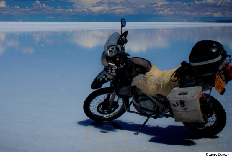
Each of the cities in this part of Bolivia has its own character – Potosi with its gritty remnants of colonial wealth and jarring mine tours; Sucre more conventionally pretty, surrounded by indigenous towns and endless back road adventures; tropical Santa Cruz, staging point for tours into sweaty lowland jungles. From Sucre few riders continue to Santa Cruz, and fewer still continue all the way into the Brazilian Pantanal on the paved road via Quijarro to Corumbá. Most prefer to double back towards the mind-bending shapes and colours surrounding the fabulous Salar de Uyuni, pictured below and rightly regarded as the best dual sport touring locales around.
The Salar salt flat often floods during the winter rains by just a few inches. While this is undeniably photogenic, the corrosive spray will eat your bike’s electrics quicker than a shoal of piranhas, possibly causing problems for months to come. During the dry season, it’s easy enough to shoot straight across directly to Chile or as an excursion from town. Either way, riding the glaring pan is surreal and exhilarating.
Descent into Chile
Two routes head from Uyuni to Chile along the southern edge of the Salar. One can be completed in a long day on actual roads to the border at Ollagüe, then on to Calama, through valleys rimmed with psychedelic shades, perfectly formed volcanoes and smaller salars choked with flamingos on diamox.
The tougher route takes a series of roads and tracks, passing Laguna Colorado and Laguna Verde before intersecting the Paso de Jama road and dropping to San Pedro de Atacama. Riders manage with neither GPS or a guide, but most will prefer to obtain a GPS track online or hire a 4x4 guide.
In all cases it’s easier to have passports stamped out of Bolivia at the migración in Uyuni, since remote border posts can be unmanned. Aduana offices remain at, or near border crossings. Bolivian fuel is cheaper than Chile so smuggling is rife and fuel is scarce. You’d want a range of 500km, otherwise ask in Ollagüe. Whatever your route, remember it gets chilly after sundown.
Other great roads in Bolivia include the spectacular ride from Oruro off the altiplano down to Arica in Chile; the mostly unsurfaced routes south from Uyuni to Tupiza, Oruro to Tarija and Sucre to Yacuiba for Argentina, as well as the routes east and north from Oruro or La Paz which descend to the Yungas jungles of the Amazon basin.
Adventure Motorcycling Handbook
Excerpts:
- Contents list
- AMH history
- Introduction
- Planning
- Choosing a motorcycle
- Life on the road
- Sample route outline (Peru and Bolivia)
- Tales from the Saddle (sample)
Price: £19.99 buy online now…
Latest tweets