Engagingly written — all the guides from this stable are first class
— Traveller
Hadrian's Wall Path
Excerpt:
About Hadrian's Wall Path
Contents | Introduction | About Hadrian's Wall Path | Planning your walk | Using this guide | Sample route guide: Heddon-on-the-Wall to Chollerford
About the Hadrian’s Wall Path
THE HISTORY OF THE WALL
Though by far the most famous, Hadrian’s Wall was in fact just one of four Roman frontiers built between the subjugated south of what is now called Britain and those tribes living in the northern part of the island, known collectively as the Caledones. Since their invasion in ad43, the Romans had at one time or another conquered just about all the tribes living on the island of Britannia. But the area we now call Scotland, once defeated, proved more difficult to keep under control. Even a potentially decisive victory in ad84 somewhere north of the Tay at a place they called Mons Graupius failed to quell the ongoing insurrection by the Caledones.
Emperors came and went before the pragmatic Domitian (who reigned ad81-96) decided that maintaining a grip over all of the island would ultimately require too many troops; troops that could be more usefully employed in other parts of the empire. It was thus decided to draw a line across the island and establish a border to separate the controllable south from those ‘lawless’ lands to the north. Initially that boundary was drawn to watch over the glens – the main gateways into and out of the Highlands – a border known as the Gask Frontier. However, as more and more troops were withdrawn from Britannia to fight in other parts of the Empire, the border by necessity receded south to the area now known, appropriately enough, as the Borders.
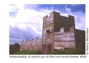
Soon after his accession, Emperor Trajan (ad97-117) decided to move the border still further south, choosing as his frontier the Stanegate (though this was not what the Romans called it), the east–west road that ran between the Roman settlements of Carlisle and Corbridge. Built during the governorship of Agricola in ad80, the Stanegate was an important trade route that needed protecting. Trajan’s troops set about building a line of turf and timber forts to guard the Stanegate, including Vindolanda (see p155) and Corbridge Roman Town (p130).
Hadrian builds his Wall
Having completely transformed the soldiers, in royal fashion, he made for Britain, where he set right many things and – the first to do so – drew a wall along a length of eighty miles to separate barbarians and Romans. Aelius Spartianus, The Augustan History
During Trajan’s reign, his fortified border was used less as a defensive barrier than as a launchpad for incursions into Scotland; an attacking border, if you like. His successor, Hadrian (ad117-138), however, saw it as more of a traditional border; as both a defensive barrier and a physical marker for the northern limit of his territories. Following a tour of his dominions in ad122, Hadrian ordered the refortification of Trajan’s border with the building of a wall to the north along the line of the Whin Sill ridge. This wall was to extend beyond the limits of the Stanegate, to stretch across the entire island. And thus the Hadrian’s Wall that we know today began to take shape.
The building of the Wall was something of an organic process, evolving as the geology and political climate dictated. This is best illustrated by the curious size of the foundations, which for much of the first half of the walk (from Newcastle west to the River Irthing) are far too broad for the wall that was eventually built upon them, suggesting, of course, that the Romans initially had plans to construct a much bigger barrier. The materials used in the Wall’s construction changed too, depending on where it was built: in the east of the country, for example, a rubble-and-puddled-clay core was used, whereas a limestone mortar core was prevalent in the middle of the country, while in the western half of the country an all-turf wall was built (though this, too, was later converted to stone sometime in the second half of the second century ad as the infrastructure improved and the supply of building materials to the line of the Wall became more efficient).
To carry out all this construction, three legions were employed: the Second Augusta from Caerleon in South Wales, the Twentieth Valeria Victrix from Chester and the Sixth Victrix from York. It was their task to clear the ground of trees and scrub where necessary and quarry, transport and organise the estimated 25 million facing stones, each approximately ten inches long, six inches high and twenty inches deep (25cm by 15cm by 50cm respectively). These were then set into the rubble-and-puddled-clay/limestone mortar core of the Wall. As a measure of the legions’ efficiency, an experiment was conducted recently in which a section of the Wall was rebuilt using some original facing stones. It concluded that a gang of 80 men needed 32 wagons and 64 oxen to keep it supplied with enough lime, water and stone to build the Wall. Yet despite all the effort required, the original construction took as little as six years to complete.
It’s a level of efficiency that becomes even more impressive when one considers the sheer enormity of the Wall, and that an estimated one ton of stone had to be dragged up for every single yard of it. Stretching from the Solway Firth to the North Sea, the Wall was 80 Roman miles long (73 modern miles) and stood at around 6m (20ft) high and just under 3m (10ft) thick. And just to ensure the security of the Wall, a 6m (20ft) ditch (Hadrian’s ha-ha, perhaps?) was dug on the northern ‘Scottish’ side along its length (though not, it must be said, around many of the crags, where the crags themselves were considered an adequate defence). A typical Roman defence, this ditch would probably have had a ‘false floor’ under which sharp spikes would have been concealed.
Such manifold defences are impressive. Yet even so, Hadrian’s Wall could act as an effective barrier only if it was sufficiently manned. So while the bulk of the men continued to be stationed in the old forts built by Trajan along the Stanegate road, milecastles (see box p112) with a capacity for 32 men were built along the entire length of the Wall at intervals of, as their name suggests, one Roman mile (the equivalent of a thousand paces) – a total of 80 milecastles in all. And evenly spaced between each one were two turrets or observation posts, 161 all told along the Wall’s entire length and always made of stone, regardless of the material of the Wall draped between them. Each was capable of holding 10 men. Estimates suggest that it would have taken just 21/2 minutes to run from one fort to the next, so messages could have been relayed along the Wall speedily.
Improving the Wall
Just a couple of years after the wall was finished the defences were strengthened, possibly in response to pressure from either the Caledones to the north of the Wall or the Brigantes – whose territory the Wall crossed. Specifically, a series of 16 forts, each housing 500 to 1000 men, was constructed at irregular intervals along the Wall. These, in many cases, replaced the forts along the Stanegate, which were either converted into supply bases or abandoned altogether. The Wall was extended too, beyond Pons Aelius to Segedunum (see p93).
In addition, 50 to 100 yards (46-91m) south of the Wall two 10ft (3m) high walls of earth were constructed, with a 10ft (3m) deep, 120ft (36m) wide ditch between them. This earthwork is known as the Vallum which, confusingly, means ‘wall’ in Latin; the name was given by the Venerable Bede, an 8th-century monk and early English historian who was the first to write about the Wall’s dimensions. (Incidentally, Bede wrote his Ecclesiastical History of the English People at his monastery in Jarrow, constructed, at least in part, from stones taken from the Wall.) Nobody is completely sure what the Vallum is for; as it is on the south side of the Wall it is unlikely to have been a defensive barrier; nor, with both the Stanegate and Military Way (see p17) nearby, would it have made much sense to construct a road here. Recent theories have suggested that the Vallum marked the border between the civilian territory and a sort of ‘military no-go zone’ surrounding the Wall. Another suggestion is that it was used to stop conscripted British soldiers, forced against their will to serve the Romans along the Wall, from running away.
The character of the Wall had now changed. From a lengthy but fairly flimsy construction whose primary purpose was a lookout from which to keep an eye on the locals, the Wall now became a defensive, heavily fortified barrier; while the number of soldiers stationed on the Wall went from a relatively measly 3000 to a much more intimidating 15,000 – a 500% increase in manpower.
It should be noted here that, although Roman soldiers built the Wall, it was Rome’s auxiliary legions who actually manned it. These soldiers were recruited from various parts of the empire – on the Wall alone you’ll come across evidence of auxiliary legions from Belgium, Germany, Spain, Iraq, Syria and elsewhere. These auxiliary soldiers were not officially Roman citizens, at least not until they had served a certain length of time in the army and had retired.
The Wall post-Hadrian
Whatever the original intentions of Hadrian, the defensive obligations of the Wall soon became rather secondary to more mundane yet lucrative financial duties. Following Hadrian’s death in ad138 his successor, Antoninus Pius, decided to push the Empire’s frontier further north once more, to a line stretching from the Clyde to the Firth of Forth. Not to be outdone, Antoninus fortified his new border with a ‘Wall’ of his own (ad142-4), the Antonine Wall, made of turf. So, just 10 years after the completion of Hadrian’s Wall, its primary purpose as a border-cum-defensive-barrier was all but finished. The character of Hadrian’s original fortifications changed too. Some forts, such as Housesteads, no longer on the front line, were left to languish and developed more into trading posts than military positions. Others, however, such as Corbridge, two miles south of the Wall, prospered as supply bases for the Roman troops stationed further north along Antoninus’s border.
Markets were established near all the forts and the local tribe, the Brigantes, soon set up small villages in the shadow of the Wall to take advantage of the trading opportunities afforded them by having the world’s first professional army, staffed by regularly paid, full-time soldiers. The new, non-military character of these forts continued even after the Antonine Wall was abandoned, c ad160, just 20 years after its inception, having been repeatedly overrun. After this, Hadrian’s Wall remained the definitive limit of the Roman Empire for the next 200 years. The forts became the business and social centres of the Wall, and villages, called vici (singular: vicus), grew up around them. In addition, a second road, the Roman Military Way, was built around ad160 between the Stanegate and the Wall, often along the northern earthwork of the Vallum (which had by now been largely decommissioned). Such a road would be vital for the rapid transport of troops along the Wall and eventually replaced the Stanegate as the primary artery adorning the neck of Britain.
It would be wrong, therefore, to think of the Wall purely as a means of defence, a place to shelter from the spears of the Barbarians to the north. Because, whatever Hadrian’s original intention for his Wall, it had evolved to become more of a checkpoint, a place to watch the comings and goings of the locals as they crossed the border, and to collect tolls and customs duties from the traders.
Severus’s restoration
That is not to say that the Wall had entirely forsaken its military duties; indeed, following a successful breach by invaders sometime around the end of the 2nd century ad, it was decided to restore, renovate and refortify Hadrian’s Wall. This took place at the beginning of the 3rd century under the reign of Emperor Severus, to whom the Wall was (wrongly) ascribed and after whom it was named for over 1500 years; prior to conclusive proof that the Wall was built during the reign of Hadrian, it had always been assumed that Hadrian had ordered the construction of the Vallum only and that it was Severus who had built the actual Wall; see box on p9.
Amongst Severus’s improvements was a rebuilding of the Wall using a super-hard white mortar which allowed it to be much narrower than previously. The Wall had never looked so good, nor so impregnable; it’s been estimated that 3,700,000 tons (30,138,000kg) of stone was used in its construction. After the Romans
Unfortunately, after the Romans had gone their greatest monument on these shores suffered. Though it had been overrun only three or four times (nobody is 100% sure exactly how many) since its original construction, when the Empire crumbled and the troops were withdrawn in ad409 the Wall was subjected to all manner of depredations and indignities. For one thing, local landowners started to remove the stone for their own purposes. Hexham Abbey (see p134) was just one beneficiary of this pilfering, with the crypt constructed entirely of Wall stone. And where the locals left the Wall untouched, the elements took their toll as wind and rain gradually wore down the remaining structure. Today, only around ten miles of the Wall are still visible.
And so it stood for centuries, forlorn and neglected if not exactly ignored. Soon it even lost its duty as a boundary between countries as the border gradually drifted north and the land to the north, now called ‘Scotland’ after the Scots tribe from Ireland who migrated centuries after the Romans had left, shrank.
Interest in the Wall was first revived, at least in print, in 1600 with the publication of Britannia by William Camden, headmaster of Westminster School in London, who attempted to explain the form, function and construction of the Wall. His work was built on a century later by the Rev John Horsley and the publication of Britannia Romania, in which, of course, the Wall featured heavily.
The General wades in
Horsley’s work revived great interest in the Wall amongst the reading public but it was not enough to prevent further damage being visited upon it during the Jacobite Uprising. In 1745, Bonnie Prince Charlie smashed his way from Scotland down through Carlisle and on to Derby before turning back. The ease with which he was able to advance so far had much to do with the fact that his adversaries, General Wade and his men, were hunkered down in Newcastle waiting to ambush him there, having assumed that Charlie would choose the eastern road for his advance.
As a result of Charlie’s success, Wade’s troops constructed the Military Road (the modern B6318) across the Pennines to enable the swift movement of troops from one side of the country to the other. (This Military Road should not be confused with the Roman’s Military Way – see p17 – though this lies nearby and performed much the same job almost 1700 years earlier.) To build this road, the Royal forces of George II removed sections of the Wall to pave their new highway. In fact, not only did they plunder the Wall for building material, they even built their road on top of it! (It should be noted that, though Wade is most associated with this road, it was actually built three years after his death.)
The Wall’s modern pioneers
Once peace had returned to Britain, Camden’s and Horsley’s works encouraged others to look at the Wall anew. Among them was the shopkeeper William Hutton who in 1802 walked from his home in Birmingham to the Wall, walked along it and back, and then walked all the way home again – a total journey of about 600 miles (966km). Taking 35 days to complete, it was an impressive feat by any standards, particularly when one considers that he was 78 years old at the time and wore the same pair of socks for the entire walk! The product of his adventure was a book, The History of the Roman Wall which crosses the Island of Britain from the German Ocean to the Irish Sea, Describing its Antient [sic] State and its Appearance in the Year 1801 – a title almost as long as the Wall itself – in which his love of Severus’s Wall (as it was still called) and his interest in its history shines through. John Hodgson and John Collingwood Bruce (whose Wallet Book of the Roman Wall, printed in 1863 and later renamed Handbook to the Roman Wall, was still being published over 100 years later) also contributed to our knowledge with books on the history and archaeology of the Wall.
Then there was John Clayton, a Newcastle town clerk in the late 19th century, who bought four of the Wall forts and to whom we owe a great debt of gratitude; without his excavation and restoration work, much of the Wall still extant would have been lost. That’s not to say Clayton’s work is unanimously admired today. In particular, his attempts to rebuild much of the Wall, taking great liberties and using largely non-Roman methods and materials, make more than one modern archaeologist weep; Clayton preferred to rebuild without mortar, so in effect the sections of Wall he rebuilt resemble a ‘modern’ drystone wall, still common around northern England, rather than the original Roman Wall. Clayton’s efforts may have ensured that there is more of the Wall visible today but it can also be argued that what we are looking at is not really the Roman Wall at all but a 19th-century reconstruction, with almost none of the Wall’s original inner core remaining. Nevertheless, to the layman, Clayton’s work is vital, the miles he ‘reconstructed’ helping us to imagine what the Wall must have looked like when first built.
The work of Clayton was continued in the 20th century by individuals such as FG Simpson (of Stead & Simpsons shoeshop fame), Eric Birley and Sir Ian Richmond, and later by bodies such as the National Trust, English Heritage and the Tyne and Wear Museums Service, organisations who concentrated less on the Wall and more on its accompanying forts and other buildings.
A proper survey of the Wall, recording every surviving remain and ruin, was conducted in 1985 to ensure there was a complete record of what exactly the authorities had in their care. And then, in 1987, UNESCO announced that the Wall was to become a World Heritage Site, thereby placing it alongside such wonders as the magnificent ruined city of Petra in Jordan, the awe-inspiring Pyramids of Giza, the mesmerising temples of Angkor Wat, the fabled lost city of Machu Picchu, the architectural dream that is the Taj Mahal and that other Great Wall, the one in northern China. The establishment in 2003 of a national trail running along the entire length of the Wall has once more brought it into the spotlight, and its instant success should ensure that millions more will enjoy the Wall’s grandeur for years to come.
HOW DIFFICULT IS THE HADRIAN'S WALL PATH?
The Hadrian’s Wall Path is just a long walk. Indeed, many rate this as the easiest of the national trails in the UK. At only four to seven days long, it’s one of the shortest too. (Indeed, there’s a guy called Elvis who works at Sainsbury’s in Haltwhistle who completed it in one 30-hour stretch for charity.)
Age seems to be no barrier to completing the walk either. While updating this edition I walked with a friend, Peter Fenner, who (and I am sure he won’t mind my revealing this) was just a month shy of his 78th birthday.
So there’s no need for crampons, ropes, ice axes, oxygen bottles or any other climbing paraphernalia, because there’s no climbing involved. All you need to complete the walk is some suitable clothing, a bit of money, a rucksack full of determination and a half-decent pair of calf muscles.
That said, it is a fairly wild walk in places. Regarding safety, there are few places on the regular trail where it would be possible to fall from a great height, unless you stray from the path near the crags; and with the Wall on one side and a road on the other, it’s difficult to get lost too. Nevertheless, you may find a compass or GPS unit (see below) useful.
Your greatest danger on the walk is from the weather. Thus it is vital that you dress for inclement conditions and always carry a set of dry clothes with you. Not pushing yourself too hard is important too, as over-exertion leads to exhaustion and all its inherent dangers; see pp72-4.
But really, while it is no mean achievement to complete the walk, this is nevertheless a straightforward but fairly exhausting stroll by the standards of northern Britain and should be enjoyed and appreciated as such.
The route is well marked with the familiar National Trail ‘acorn’ signposts, arrows and other waymarks, so keeping to the trail shouldn’t really be a problem.
GPS
Whilst modern Wainwrights will scoff, more open-minded walkers will accept that GPS technology can be an inexpensive, well-established if non-essential navigational aid. In no time at all a GPS receiver with a clear view of the sky will establish your position and altitude in a variety of formats, including the British OS grid system (see pp209-11), to within a few metres. However, a GPS is not a replacement for a map and compass. Although modern units are robust and durable, it only takes a flat battery to render them useless. You should view the two systems as compatible and use both older and newer technologies together. A GPS will prevent you from making exaggerated errors when navigating and will reduce the time it takes to correct mistakes if you do stray off the path.
Using GPS with this book is an option. Without it you could conceivably end up ambling confidently along the wrong path (though with all the paths well waymarked and given the detail on the maps in this book it would actually be quite an achievement to get lost!). However, with GPS you can quickly establish your position and work out how to return to your last known position on the trail.
Using GPS with this book
It is not expected that you will walk along checking off the GPS waypoints found throughout the book, since the detailed maps and route descriptions are more than sufficient for finding your way most of the time. Only when you are unsure of your position or need reassurance as to which way to go might you feel the need to reach for your GPS for confirmation.
The maps in the route guide include numbered waypoints; these correlate to the list on pp209-11, which gives the latitude/longitude position in a decimal minute format as well as a description. Where the path is vague, or there are several alternatives, you will find more waypoints. Typically landmarks or other significant features are also waymarked. Waypoints are less common in towns or villages but can still be found to help you pin down the path ahead or identify a junction.
You can manually key the nearest presumed waypoint from the list into your GPS as and when the need arises. Alternatively, with less room for error when inputting the co-ordinates, download the complete list for free as a GPS-readable file (that doesn’t include the text descriptions) from the Trailblazer website. You’ll need the correct cable and adequate memory in your unit (typically the ability to store 500 waypoints or more). The file as well as instructions on how to interpret an OS grid reference can be found on the Trailblazer website: : www.trailblazer-guides.com (click on GPS waypoints).
It’s also possible to buy state-of-the-art digital mapping to import into your GPS unit, assuming that you have sufficient memory capacity, but it’s not the most reliable way of navigating and the small screen on your pocket-sized unit will invariably fail to put places into context or give you the ‘big picture’. This is also a far more expensive option than buying the traditional OS paper maps which, whilst bulkier, are always preferable.
Bear in mind that the vast majority of people who tackle the Hadrian’s Wall Path do so perfectly successfully without a GPS unit. Instead of rushing out to invest in one, consider putting the money towards good-quality waterproofs or footwear instead. That said, a GPS unit may assist in the odd dicey decision, and if used correctly in tandem with this book’s waypoints might just see you safely to the next pub or overnight stop that much more quickly.
HOW LONG DO YOU NEED?
According to the statistics (see box opposite), people take an average of around six days to complete the walk, making it one of the shorter national trails. Of course, if you’re fit there’s no reason why you can’t go a little faster, if that’s what you want to do, and finish the walk in five days (or even less), though you will end up having a different sort of trek to most of the other people on the trail. For where theirs is a fairly relaxing holiday, yours will be more of a sport. What’s more, you won’t have much time to enjoy the forts and other attractions, one of the main reasons for visiting the Wall in the first place. There’s nothing wrong with this approach – chacun à son goût, as the French probably say. However, what you mustn’t do is try to push yourself too far. That road leads only to exhaustion, injury or, at the absolute least, an unpleasant time. When deciding how long to allow for the trek, those intending to camp and carry their own luggage shouldn’t underestimate just how much a heavy pack can slow them down. On p40 there are some suggested itineraries covering different walking speeds. If you have only a few days, don’t try to walk it all; concentrate instead on one area such as the popular central section, or the quieter Cumbrian section from Carlisle to Bowness.
Hadrian's Wall Path
Excerpts:
- Contents
- Introduction
- About Hadrian's Wall Path
- Planning your walk
- Using this guide
- Sample route guide: Heddon-on-the-Wall to Chollerford
Price: £15.99 buy online now…
Latest tweets