These Trailblazer guides … are a godsend for independent travelers.
— Travel & Leisure
Hadrian's Wall Path
Excerpt:
Introduction
Contents | Introduction | About Hadrian's Wall Path | Planning your walk | Using this guide | Sample route guide: Heddon-on-the-Wall to Chollerford
Just when you think you are at the world’s end, you see a smoke from East to West as far as the eye can turn, and then under it as far as the eye can stretch, houses and temples, shops and theatres, barracks and granaries, trickling along like dice behind – always behind – one long, low, rising and falling, and hiding and showing line of towers. And that is the Wall! Rudyard Kipling, Puck of Pook’s Hill
On 23 May 2003, Britain’s 13th National Trail, Hadrian’s Wall Path, was opened in the border country between England and Scotland. The trail (84 miles/135km from end to end) follows the course of northern Europe’s largest surviving Roman monument, a 2nd-century fortification built on the orders of the Emperor Hadrian in ad122. The Wall marked the northern limits of Hadrian’s empire – an empire that stretched for 3000 miles across Europe and the Mediterranean all the way to the Euphrates. Such is the archaeological and symbolic importance of the Wall that in April 2006 the original list of ‘Icons of Britain’ was expanded to include it as representative of Roman Britain, just as Stonehenge is of the Neolithic Age.
To say that creating such a path had been problematic would be something of an understatement. This was the first National Trail to follow the course of a UNESCO World Heritage Site. As such, every time a fencepost, signpost or waymark was driven into the ground, an archaeologist had to be present to ensure that the integrity of the Wall was not in any way compromised. To give you an indication of just how careful they had to be, it took ten years before the Hadrian’s Wall Path was finally opened to the public. By comparison, it had taken the 2nd and 6th legions of the Roman army only six years to build the actual Wall!
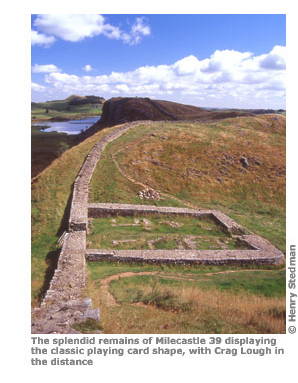
Since its opening many have walked the trail and all seem to agree that the difficulties involved in its creation were well worth it, allowing the walker to follow in the sandal-steps of those who built it – the trail itself rarely diverts from the course of the Romans’ barrier by more than a few hundred metres. And, though there’s only about ten miles of the Wall left and it hardly ever rises to more than half its original height, it – or at least the route it would have taken – makes for a fascinating trekking companion. Punctuated by forts, milecastles and turrets spaced evenly along its length, the Wall snaked over moor and down dale through Northumberland and Cumbria, between the Roman fort of Segedunum (at the appropriately named Newcastle suburb of Wallsend) in the east and the mouth of the Solway River in the west. It’s an incredible feat of engineering, best appreciated in the section from Housesteads to Cawfield Quarry where the landscape is so bleak and wild that human habitation and farming never really took a hold. It is here that the Wall stands most intact, following the bumps and hollows of the undulating countryside – as integral a part of the scenery now as the whinstone cliffs on which it is built. Here, too, are some of the best-preserved fortresses, from the vast archaeological trove at Vindolanda, set just off the Wall to the south, to the subtle charms at Birdoswald and the beautifully situated Housesteads itself.
After the Romans withdrew the Wall fell into disrepair. What we see as a unique, awe-inspiring work of military architecture was to the local landowners a convenient source of ready-worked stones for their own building purposes. The Wall is part of the fabric of many of the major constructions built after the Romans left: the priories and abbeys that lie just off the Wall, such as those at Hexham and Lanercost; the Norman castles at Carlisle and Newcastle; the Military Road which we follow for part of the walk; the stronghouses at Thirlwall and Drumburgh – all beautiful, historically important buildings. And all of them incorporate stones from the Wall. Yet even where its destruction was total, the Wall’s legacy continues to echo through the ages in the names of the villages that lie along the route: Wallsend, Wallend, Wallhouses, Walton, Wall village and Oldwall are just some of the place names that celebrate the Wall. The past is inseparable from the present.
Quite apart from the architectural and historical interest, all around the Wall is scenery of breathtaking beauty, from the sophisticated cityscape of Newcastle to the wild, wind-blasted moors of Northumberland, the pastoral delights of Cumbria’s appropriately named River Eden and the serenity of Bowness-on-Solway, an Area of Outstanding Natural Beauty and a haven for birdwatchers and those seeking peaceful solitude.
Yet perhaps the best feature of the Wall is that all its treasures are accessible to anyone with enough get-up-and-go to leave their armchair. The path itself is regarded as one of the easiest National Trails, a week-long romp on a grassy path through rolling countryside with the highest point, Green Slack, just 345m above sea level. (That said, there are still a couple of tiring stages.) The waymarking is clear and, with the Wall on one side and a road a little distance away on the other, it’s very difficult to lose one’s way. There are good facilities, from lively pubs to cosy B&Bs, friendly, well-equipped hostels and idyllic little tearooms. And for those for whom completing the entire trail is over-ambitious, there are good transport connections, including a special Hadrian’s Wall Country bus (the AD122). With a little planning, you can arrange a simple stroll along a short section of the trail, maybe take in a fort or museum on the way, then catch the bus back to ‘civilisation’. While for those who prefer not to follow any officially recognised National Trail, the path also connects to 43 other walks, details of which are readily available from one of the half-dozen or so tourist offices serving the trail.
So, while the Wall no longer defines the border between Scotland and England (90% of Northumberland, an English county, actually lies to the north of the Wall, and at no point does the wall actually coincide with the modern Anglo-Scottish border), it nevertheless remains an inspiring place and a monument to the breathtaking ambition of both Hadrian, the youthful dynamic emperor, and of Roman civilisation itself. And this trail is a great way to appreciate it.
About this book
This guidebook contains all the information you need. The hard work has been done for you so you can plan your trip from home without the usual pile of books, maps, guides and tourist brochures. Pre-departure planning information includes:
- Descriptions of all kinds of accommodation from campsites to luxurious guesthouses
- Walking companies if you want an organised tour
- A number of suggested itineraries for all types of walkers
- Answers to all your questions: when to go, degree of difficulty, what to pack and how much the whole walking holiday will cost
When you’re all packed and ready to go, there’s comprehensive information to get you to and from the Hadrian’s Wall Path and 59 detailed maps and town plans to help you find your way along it. The route guide section includes:
- Walking times in both directions
- GPS waypoints to aid navigation and for those who want to plot their path on a GPS
- Reviews of campsites, bunkhouses, hostels, B&Bs, guesthouses and hotels
- Cafés, pubs, tearooms, takeaways and restaurants as well as shops for buying supplies
- Rail, bus and taxi information for the villages and towns along the path
- Street plans of the main towns both on and off the Wall: Newcastle, Wylam, Corbridge, Hexham, Haltwhistle, Brampton and Carlisle
- Historical, cultural and geographical background information
Hadrian's Wall Path
Excerpts:
- Contents
- Introduction
- About Hadrian's Wall Path
- Planning your walk
- Using this guide
- Sample route guide: Heddon-on-the-Wall to Chollerford
Price: £15.99 buy online now…
Latest tweets