Worth watching out for.
— John Cleare
Norway's Arctic Highway
Excerpt:
Sample route guide
Contents list | Introduction | Planning your trip | Driving the Highway | Sample route guide
 For much of the journey to Karasjok, the Arctic Highway turns to inland routes over the vidder which separate the fjords before finally heading southwards into the interior of Finnmark. Most of this path is, not surprisingly, uninhabited – except by the Sami in their summer camps. It will be prudent, therefore, to fill fuel tanks when the opportunity occurs even if they are already half full. Accommodation, too, is not easy to come by and choice is limited even in those settlements such as Skaidi, Lakselv and Karasjok which are on the Highway's route.
The Highway: Alta to Skaidi
Maps 12�13
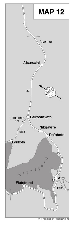
The Arctic Highway leaves Alta through the district of Kronstad, crosses the T�fossen bridge over Tverrelva and rejoins the coast just after passing the mouth of the narrow Transfordalen. Back with the shore means a return of views out to the fjord and, sharply westward, to the town of Alta. The Highway is now running along the shore of Rafsbotn, an easterly arm of Altafjorden which, with K�fjorden, gives the whole fjord the shape of an inverted T.
Rafsbotn (18km; NB distances from Alta assume the Bossekop junction as the centre of Alta) is a small fishing village, with a store (right), but the Highway skirts by to begin its climb through a gorge away from the fjord. From here to Skaidi, 80km away, the country is wild and desolate.
Slopes on either side of the Highway are steep but birch trees often manage to find a root-hold in the scree. The road's gradient lessens at about 200m and the forest thickens. By the time you reach the top of the rise, there are only scattered trees and bog. Thus begins ‘the land of the cotton grass’, the tundra, true Lapland. Cotton grass is typical tundra vegetation, seeking out the damp ground and growing round, and even in, shallow ponds and lakes, which rest on the peaty surface or in the ill-drained active zone above the permafrost.
Along the roadside, and especially at a place called Nibijavrre (24km), you begin to see the summer huts of the Sami whose reindeer find food and shelter in the thin forest of this wasteland. The huts, mostly to the right of the Highway, are the houses for the short summer of Sami from the Kautokeino district. Often the whole family will be in residence, sometimes just the young adults. The huts here are poorer than those on Sennalandet further along the Highway. Typically the area around the huts will be an untidy collection of snow scooters, the occasional sledge and the detritus of family living. You may find a tent erected near to the road as a tourist-lure, with skins and antlers for sale.
From this higher ground the Highway descends 50m to Leirbotnvatn (29km) in the company of a stream (to the right of the road) which matches the Highway's gradient with its shallow falls over a rocky bed. Leirbotnvatn, a large lake at the head of Lakselvdalen, is at the junction with Route 883 (see Side trip 3 from Alta, Part 7, p231).
The Highway's route continues up Stokkedalen. This requires a steady climb on a consistent gradient. The road has been built above valley level such that there are steep slopes up to the left of the Highway while, to the right, the land falls away down to the largely unseen river. The valley is tree-filled and a favourite place for the Sami's reindeer to forage. Despite the erection of some fences and crude reindeer-scares, the deer quite frequently dash wildly across the road and an unexpected encounter with a car will leave the animal dead and the vehicle damaged. It is best to watch carefully and always give the reindeer right of way.
Below the Highway, to the south-west, the river runs in a gorge which narrows towards the head. As the road climbs towards the plateau above the gorge the forest begins to thin and at about 375m the path levels and the Highway is ready to cross the Senna vidde. Now you'll see no trees, no habitation, simply bare rock, patchy grass and bog. This tundra scenery is reminiscent of the Saltfjell where the Arctic Highway crosses the Polar Circle (see Part 4, p131).
The route taken by the Highway to cross the vidde is mostly close to the plateau's watershed. This is no mountain ridge; the rivers scarcely cut into the landscape. It is all remarkably flat and this adds to the desolation. When I first travelled the Highway many years ago it was little more than a waterbound gravel track which, after spring thaw or rain, was difficult to negotiate as it became rutted by the few vehicles that used it. Its only redeeming feature was that it was straight.
Today's Highway is even straighter but it is raised, widened and well surfaced. It used to be impossible to keep the Sennalandet section open through the winter. Now there will be temporary closures in the worst of the winter snowfalls but it is essentially an all-weather road.
No one lives on the vidde but in summer between late May and early September, the Sami from Kautokeino and Masi (see Part 7, p226) move here to watch over their reindeer after the spring migration. There is a scattering of huts at first and then, towards �is�roaivi (also called Aisaroiui; 50km), there is what comes close to being a Sami village. This concentration of huts is explained not only by the people's wish to live in a more socially coherent community but also by the presence of a small chapel, a slaughterhouse and springs for water supply.
When I made the first study of Áisároaivi in the 1970s (Nomads of the Arctic) many of the Sami families had just begun to move their huts to this area where the Highway crosses the head-waters of Repparfjordelva. Now this loose agglomeration is established but the huts and the primitive living conditions are much the same. The loneliness of the tundra is ameliorated by living in this community but, when the sleet is blown across the vidde from leaden skies, there is little to envy in the life of the Sami at Áisároaivi.
The little chapel lies to the left of the Highway and you can see it clearly. It is usually kept locked except when, on the occasional Sunday in summer, a service is held. Then the Sami walk down the tracks that link their widely separated huts with the Highway and assemble in the tiny wooden building for a service in Norwegian and Sami. Afterwards they move back to the huts to share endless cups of coffee with their neighbours. Theirs is a very private life and if you wander off the Highway into their settlement, you are not generally welcome. Not so those who buy whatever they have for sale in tents and crudely erected wooden lean-tos that are set up against the road.
Beyond Áisároaivi the Sami encampments are fewer but, as you descend to 250m and below, the birch woods reappear in the shelter of the valley and, tucked in among the trees, are the summer cabins belonging not to the Sami but to Norwegians who fish the river. The river is the Repparfjordelv and the Highway shares its valley, running high above the stream and its salmon-rich waters.
As the Highway approaches Skaidi the valley of the Repparfjordelv, here called Breidalen, narrows. The river is entrenched in a gorge within a gorge. At first the road follows the river but at about 200m it levels out and drops less steeply, eventually running on a shelf some 60m above the river. Much resurfacing and straightening of the Highway has taken place here in recent years and many of the more difficult sections have been rebuilt by the simple expedient of explosive charges placed in the rock walls. The gorge, however, still acts like a funnel, strengthening the winds blowing through it. As a consequence, the trees are stunted, almost stump-like, and above the gorge there is only rock and bog.
The gorge broadens into a valley as you reach Skaidi (87km). Skaidi is a textbook example of a service settlement resulting from a major road junction. The name means ‘River Meeting’. The Highway turns right into the village but to the left is Route 94 leading to Hammerfest. The village is well served by a hotel and a motel. There is a store and the village is an ideal place for you to stop and re-provision. There is a tourist kiosk (tel 78 41 62 80), to the right of the road, open in summer.
Accommodation: Alta to Skaidi
There's not a lot of choice other than to stop at Skaidi. Even wild camping isn't very practical. At Skaidi the Skaidi Arctic Hotel (tel 78 41 61 20; fax 78 41 61 27) is open all year but, in winter, accommodation has to be pre-booked. The hotel has 44 rooms of which nine are singles. As so often in Norwegian hotels, the singles convert to doubles and the doubles to triples.
The hotel is close to the centre of the village to the left of the Highway. There are smoking and non-smoking lounges, a restaurant which is open most of the day, a swimming pool, sauna and solarium. Four rooms have their own sauna. With rates at NOK400�500 (including breakfast), this is an excellent stopover option.
There is also the Skaidi Kro og Motell (tel 78 41 61 23; fax 78 41 61 59) just after the hotel. This is really a café-cum-guesthouse. It has just eight rooms and the prices are only a little below those of the hotel.
Norway's Arctic Highway
Excerpts:
- Contents list
- Introduction
- Planning your trip
- Driving the Highway
- Sample route guide
Latest tweets