Wonderful handbooks
— The Bookseller
Peddars Way and Norfolk Coast Path
Excerpt:
Sample route guide: Knettishall Heath to Little Cressingham
Contents | Introduction | About the Peddars Way & Norfolk Coast Path | Practical information for the walker | Itineraries | Using this guide | Sample route guide: Knettishall Heath to Little Cressingham
KNETTISHALL HEATH TO LITTLE CRESSINGHAM MAPS 1-8
Easy-going and well-maintained paths make this first 141/2 miles (23km, 5hrs)
from Knettishall Heath, actually in Suffolk, a gentle introduction to the trail and
the route ahead. Meandering through tranquil woods the path, formerly a
Bronze Age trading route and Roman road, quickly crosses into Norfolk and breaks out
across farmland before beginning to cross a series of attractive heaths where you can begin
to appreciate the scale of the landscape. Before you begin, bear in mind that accommodation
on the early stages of the Peddars Way is scarce and make sure you have something booked.
Alternatively, be prepared to detour from the path and try your luck in one
of the larger villages close by. 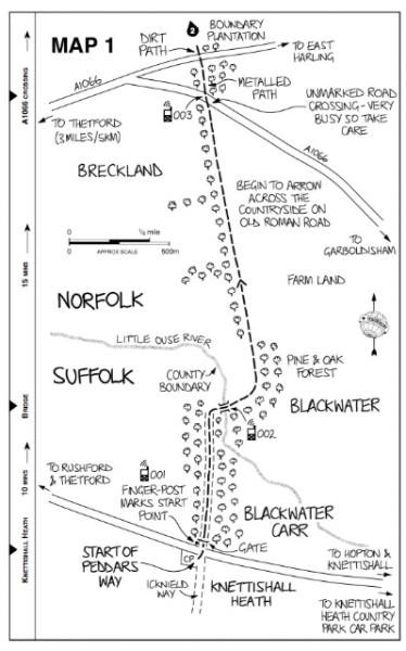
To get to the start of the Peddars Way from Coney Weston, head west on Thetford Rd. Turn right at a crossroads and head north on Norwich Lane until you reach a T-junction where you turn right to Knettishall Heath.
The Peddars Way in fact begins rather quietly from a finger-post adjacent to a B road, next to Blackwater Carr – a surprisingly low-key and easy-to-miss way of signalling the start of a National Trail. Opposite is a car park with no facilities but this is where the Brecks Bus (see p45) stops; it is also where the Icknield Way (see p31) ends. At the nearby Knettishall Heath Country Park, however, there is a pay and display car park with public toilets.
Pass through the gate beyond the finger-post and head roughly straight on into a light wood. After 700m bend right and cross the Little Ouse, leaving Suffolk and entering Norfolk, where you pass through Breckland (see p50), a landscape of light, dry, sandy soils bound together by Scots pine and conifer plantations.
Passing through attractive woods, the path climbs gently to a pair of main roads and then meanders alongside a forest on a raised Roman causeway (or agger) almost 5m wide, until it arrives at the River Thet. To the east of here is Thorpe Woodlands Caravan Park and Campsite. However, campers can stay here only if they have a chemical toilet since there are no facilities on site.
Just before the River Thet there is a section of duckboards which continue once you have crossed the river on a small humpback bridge, useful as the ground can be marshy and wet here, and then cross a minor road. Following the road there are excellent views of Brettenham Heath to the west, one of the largest areas of heathland in Norfolk and a haven for birdwatchers. Cross the A11, a dual carriageway connecting London and Norwich, and the Ely–Norwich railway line at a level crossing, to re-enter the woods.
Beyond a gas pipeline pump station the path climbs gently alongside
farmland and piggeries. Having crossed another minor road it ambles alongside
the disused Thetford–Watton railway line and past a farm to pass eventually
between the abutments of an old railway bridge and arrive at Stonebridge.
Peddars Way and Norfolk Coast Path
Excerpts:
- Contents
- Introduction
- About the Peddars Way & Norfolk Coast Path
- Practical information for the walker
- Itineraries
- Using this guide
- Sample route guide: Knettishall Heath to Little Cressingham
Latest tweets