'These human-scale books, written and published by people who genuinely know and love their subject, are perfect for travel's post-pandemic recovery.'
— The Guardian, March 2021
Sinai - The Trekking Guide
Excerpt:
Sample trek: Jebel Berqa
Contents | Introduction | Planning your trek | When to go | Route options | Sharm el Sheikh | High Mountain Region | Sample trek: Jebel Berqa | Sinai desert trekking routes map
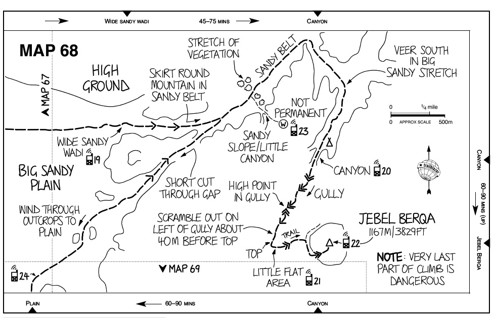
Onwards to Jebel Berqa [Maps 67-68]
Go down and head east over the plain; it’s a long trudge but is perfect for honing some camel skills. Aim for a wide, sandy wadi on the left side of Jebel Berqa (GPS 19). This rises gradually uphill and merges into a sandy belt that runs round the northern flanks of the mountain. Circle around in this belt, following the general line of the rocky ground on your right. You soon reach a wide wadi that runs directly south towards the peak. A small canyon opens up at the far end and you start the ascent to the summit here (GPS 20).
Water near Jebel Berqa
A conspicuous stretch of vegetation runs across the sandy belt a short way round – mostly big, healthy retem bushes (see p64). Follow its line up to the low flanks of the mountain. A small canyon opens in the rocks here with a sandy slope on its left side. Go up the sandy slope and follow a new canyon that opens behind it. There’s a natural pool near the end (GPS 23). It’s not permanent but it usually stays for a couple of months after rain. The desert wildlife uses it heavily, as you’ll see by all the tracks, and it’s usually a thick, slimy green. Use it to water camels or just keep a bit for an emergency.
Camping around Jebel Berqa
Most guides prefer to stay outside the canyon where you climb to the peak but there are plenty of other spots.
Jebel Berqa: the ascent [Map 68]
At 1167m Jebel Berqa is one of the desert’s highest peaks. It’s mostly a moderate scramble but there’s an exposed climb up the top rock band. It’s best to take your own rope if you want to try it. You go up and down the same way and you need 2-3 hours for the return. Sunset and sunrise are spectacular around here and it’s worth trying to catch one from the top.
Enter the canyon and follow it ahead. It soon becomes a steep, bouldery gully where you have to scramble. Further up there’s a natural high point where views extend over the gully’s final stretch. Move down and continue straight up. About 40m before the top of the gully you have to scramble out on the left hand side. Look for a place where the rocks have been whitened by all the feet.
Once up here walk along the rocky side of the gully on exactly the same line as its course below. A short, steep scramble above the top of the gully brings you to a small flat area capped with a few boulders (GPS 21).
Turn left and follow a steep trail towards the summit. It divides and goes either side of the top rock band: go right, moving south.
You soon reach an obvious point where you can climb the rock band – the way has been smoothed out. It’s about 10m high, nearly vertical, and above steep, exposed slopes. Bits of loose rock remain on the cliffs, so take extra care. Only try it if you’re a good experienced scrambler with your own rope – there are a few anchor stakes hammered in. Don’t use ropes rigged on the cliffs. The desert air wears their inner fibres away and they can snap easily.
The peak has magnificent views over the desert (GPS 22). Looking east you’ll see the rugged flat top of Jebel Mileihis – the final summit in this route. On a good day the Hejaz ranges stand out beyond. Far away to the north is a peak that looks a bit like Jebel Berqa: this is Ras el Qelb and it stands just north of the Ein Umm Ahmed oasis – which isn’t in view.
Moving on from Jebel Berqa
There are plenty of interesting spots to explore around Jebel Berqa, including small canyons and some dunes at a wadi called El Brayga (ask your guide). You could stay here, or at least close by, for another night, scheduling to arrive at Ein Hudera later.
Sinai - The Trekking Guide
Excerpts:
- Contents
- Introduction
- Planning your trek
- When to go
- Route options
- Sharm el Sheikh
- High Mountain Region
- Sample trek: Jebel Berqa
- Sinai desert trekking routes map
Price: £14.99 buy online now…
Latest tweets