Trailblazer guidebooks provide practical information on specific routes in less accessible parts of the world.
— Wanderlust
Preview an Excerpt
Tour du Mont Blanc
- Route guide and maps, plus guides to Chamonix & Courmayeur
by: Jim Manthorpe
Price: £16.99 BUY NOW
ISBN 978-1-912716-36-4
3rd edition
192 pages
50 maps
60 colour photos
120mm x 180mm 5" x 7"
- 'I would highly recommend this Trailblazer guide’
- Strider - ...the complete guide to one of the exciting areas of the Alps...
- Strider, Journal of the Long Distance Walkers Association
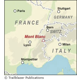 At 4810m (15,781ft), Mont Blanc is the highest mountain in western Europe. The snow-dome summit is the top of a spectacular massif of peaks stretching 60 miles by 20 miles, arguably the most magnificent mountain scenery in Europe.
Circumnavigating the massif and passing through France, Italy and Switzerland, the Tour du Mont Blanc is a waymarked trail of 105 miles (168km), taking 10-14 days.
50 detailed trail maps - with comprehensive route descriptions
- Unique mapping features - walking times, directions, tricky junctions, places to stay, places to eat, points of interest; these are not general-purpose maps but full edited maps drawn by walkers for walkers
- Practical information for all budgets - where to eat, what to see, where to stay: gîtes, hostels, lodges, hotels, campsites
- Comprehensive background information - the Alps, flora and fauna, the history of mountaineering and trekking in the region and the conquest of Mont Blanc in 1786 by Bourrit and Balmat
- Plus - detailed guides and town plans for Chamonix, Argentière and Courmayeur
- Now includes what3words waypoints
Updates:
Latest Updates for Tour du Mont Blanc
Price: £16.99 buy online now…
Latest tweets