Trailblazer Guides are produced by people who know exactly what information is needed - not just to get from A to B but to be entertaining as well as informative.
— The Great Outdoors
New Zealand - The Great Walks
Excerpt:
Using this guide
Contents list | Introduction | Planning your tramp | Using this guide | Sample route guide | Sample track description
 'Above all do not lose your desire to walk. Everyday I walk myself into a state of well-being and walk away from every illness.
I have walked myself into my best thoughts and I know of no thought so burdensome that one cannot walk away from it.
But sitting still, and the more one sits still, the closer one comes to feeling ill ... thus if one just keeps walking, everything will be alright.'
Soren Kierkegaard, quoting words attributed to Buddha, in a letter, 1847
ROUTE MAPS
Scales and walking times
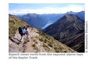
For each Great Walk, there is an overview map that shows the whole route and puts all the huts into context. This is drawn at a larger scale (ie less detailed) to the route maps that correspond to each day's tramping.
The map scale of the route maps varies slightly (between 1:40,000 and 1:80,000) from one track to the next, depending upon the length and distance covered in the course of each tramp.
However, the maps within each tramp are drawn at the same scale so as to provide a consistent level of detail; each map also represents one full day's tramping from hut to hut. However, you may choose to create your own itinerary.
Approximate walking times are also indicated on each map. There are too many factors that can affect walking speed, such as the size of the group, level of fitness and the state of the weather; as such, they should be used as a rough guide only.
Note that they refer to walking time only and do not include any time for breaks or food. The arrows show to which direction the walking time refers. Finally, there are map keys on p281.
Gradient arrows
The track is marked as a dotted line. An arrow across the trail indicates a slope and always points uphill. Two arrows placed close together means that the gradient is steep.
Note that the arrow points towards the higher part of the trail. If, for example, you are walking from A (at 80m) to B (at 200m) and the trail between the two is short and steep, it would be shown thus: A - - - >> - - - B.
Fees
In the following guide an adult is deemed to be 18 years and over. Youth groups are defined as those aged 11 to 17 and children are aged 5 to 10. Pre-school age is self-explanatory. Fees are charged per person, per night.
In 2008 the Department of Conservation decreed that child and youth groups could stay in DOC huts free of charge, although a booking is still required.
Latest tweets